Catalog Archive
Auction 163, Lot 294

"[Untitled - Lower Mississippi River]", Le Page du Pratz

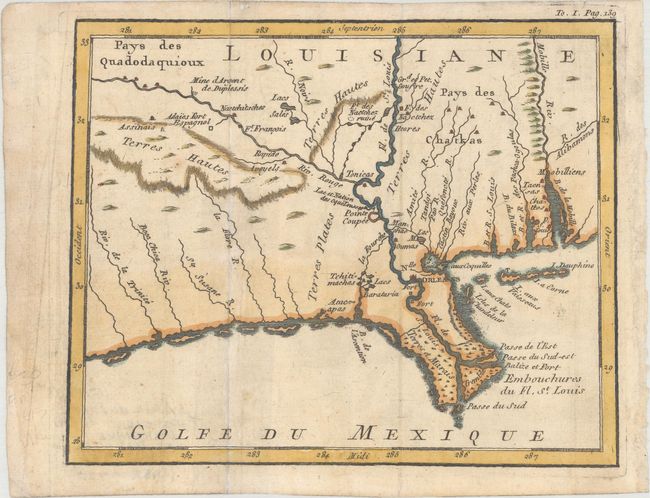
Subject: Colonial Louisiana, Lower Mississippi River

Period: 1758 (published)

Publication: Histoire de la Louisiane...

Color: Hand Color

Size:
7.3 x 5.9 inches
18.5 x 15 cm
Download High Resolution Image
(or just click on image to launch the Zoom viewer)

This scarce map depicts the lower Mississippi. It centers on New Orleans and spans from Trinity River in Texas to Mobile Bay. The Mississippi River, here labeled as Fl. de St. Louis, is prominently shown with nice detail of its mouth at the Gulf of Mexico. Several smaller rivers in the region are delineated, most notably the Red River, and lakes and bays are named as well. Several forts are located, including Fort Natchez and the ruins of a former Fort Natchez site. Indian lands, marshlands, highlands, and a silver mine are identified as well.

Le Page du Pratz, a French military engineer, resided in Louisiana in the early part of the eighteenth century. During this period he made a five-month tour of the interior of Louisiana. On his return to France he wrote this important history of Louisiana based on his own adventures combined with information from other French explorers including Bourgmont, Charlevoix, and Dumont de Montigny. Thomas Jefferson owned the English edition of Le Page du Pratz’s work and used it as a reference source for his treatise on Louisiana. Meriwether Lewis took a borrowed edition on the expedition to the Pacific and made several references to the work in his journal of the expedition.

References:

Condition: B+

A nice impression issued folding, now flat, with very light soiling, an archivally repaired fold separation at bottom left, and a small infilled worm hole at top right with a minute portion of the border replaced in facsimile.

Estimate: $400 - $500

Sold for: $175

Closed on 6/14/2017

Archived