Catalog Archive
Auction 163, Lot 160

"Louisiana, as Formerly Claimed by France, Now Containing Part of British America to the East & Spanish America to the West of the Mississippi. From the Best Authorities", Kitchin, Thomas

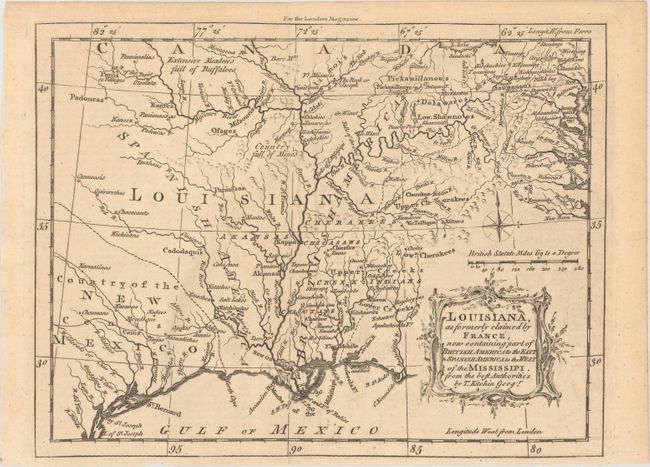
Subject: Colonial Southern United States

Period: 1765 (published)

Publication: London Magazine

Color: Black & White

Size:
9.1 x 6.9 inches
23.1 x 17.5 cm
Download High Resolution Image
(or just click on image to launch the Zoom viewer)

This well-engraved map focuses on the Mississippi River valley and spans the region from Lake Erie to the Gulf Coast. Completed after the conclusion of the French and Indian Wars, the map shows the British and Spanish claims in the region formerly belonging to France, with Britain owning the land east of the Mississippi, including Spanish Florida. To compensate her ally Spain for the loss of Spanish Florida, France gave Spain the land west of the Mississippi. Cenis is named in present-day Texas, which is here labeled as Country of the New Mexico. The map is filled with interesting details, such as the Extensive Meadows Full of Buffaloes located north of the Missouri River and the Country Full of Mines noted in present-day Missouri. It is adorned with a typically delicate and lovely cartouche engraved by Kitchin.

References: Sellers & Van Ee #724; Jolly #LOND-245; Lemmon, Magill & Wiese #39.

Condition: A

A crisp impression issued folding with faint toning and a hint of offsetting.

Estimate: $350 - $425

Sold for: $150

Closed on 6/14/2017

Archived