Catalog Archive
Auction 163, Lot 158

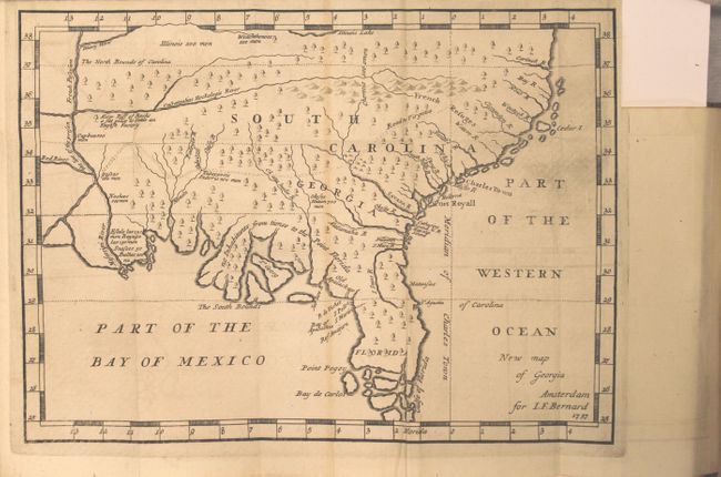
One of the Earliest Published Maps of the English Colony of Georgia

"New Map of Georgia [in book] Recueil de Voiages au Nord...Tome Neuvieme", Bernard, Jean Frederic

Subject: Colonial Southern United States

Period: 1737 (published)

Publication:

Color: Black & White

Size:
10.3 x 7.5 inches
26.2 x 19.1 cm
Download High Resolution Image
(or just click on image to launch the Zoom viewer)

This scarce map is one of the earliest published maps of the English colony of Georgia. It is a somewhat larger example that was apparently taken from the 1733 map in Martyn's Reasons for Establishing The Colony of Georgia, although with numerous errors and omissions. This map has also been attributed to James Oglethorpe, founder of the British Georgia colony in 1732, and presents extensive English claims southward to just north of St. Augustine, no doubt inflaming Spanish interests at the time. This hostility led to the War of Jenkins Ear in 1739. The map covers the region from Florida and up the east coast extending north to above the Cartuck River at the northern border of South Carolina. It extends west to beyond the Mississippi River, showing all of colonial South Carolina, Georgia and Florida. The southern portion of Florida is composed of numerous islands. A southerly bloated coast along the Florida panhandle suggests vast lands that could be utilized by farmers under the “Oglethorpe Plan” for colonization. Coincidentally, the lands end at the line demarcating “The South Bounds of Carolina”. Few settlements are identified, with the exception of Charles Town, Port Royall, St. Augustine and a few others, and the prime meridian is drawn at Charleston. This map also includes notations related to the number of men in various Indian tribes: Illinois 500 men, Weachthenoes 500 men, Okesee Nation 700 men. A fascinating map that was clearly constructed to promote the Georgia colonization efforts.

The map is still bound into Bernard's ninth volume of Recueil de Voiages au Nord.... The 464 pages of text are divided into two parts describing relations with the Natchez Indians, and the land between New Mexico and the "frozen sea." 16 mo., hardbound in full contemporary leather with gilt title label, tooling, and raised bands on spine.

References: Cumming (SE) #234; Sabin #4936.

Condition: A

A dark impression on watermarked paper with very faint offsetting and one thin line of faint toning. The text is clean, bright, and flawless. Covers are lightly rubbed with minor chips, and the spine has some minor cracking.

Estimate: $1,600 - $1,900

Sold for: $850

Closed on 6/14/2017

Archived