Catalog Archive
Auction 163, Lot 109

First Edition of Melish's Map of the United States

"[2 Volumes] Travels in the United States of America, in the Years 1806 & 1807, and 1809, 1810, & 1811; Including an Account of Passages Betwixt America and Britain...", Melish, John

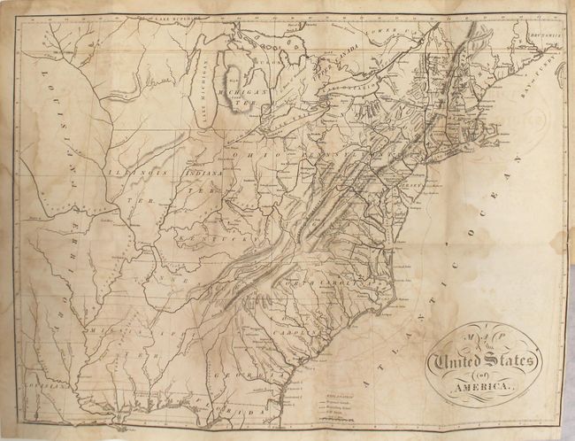
Subject: Eastern United States

Period: 1812 (published)

Publication:

Color: Black & White

Size:
5.5 x 8.6 inches
14 x 21.8 cm
Download High Resolution Image
(or just click on image to launch the Zoom viewer)

This is the first edition of Melish's Travels in the United States of America and includes a total of 8 maps (4 folding) between the two volumes. Melish was the first American publisher to concentrate on cartographic and geographic publications. Born in Scotland, Melish emigrated to the United States intent on farming. After traveling some 2,400 miles throughout the northeast looking at land, he finally settled on Philadelphia in 1811. A year later, he published Travels which included his very first maps. He soon came to dominate the industry in this country, and had a huge impact on all subsequent American map-making.

The frontispiece to volume 1 is Melish's famous Map of the United States of America (17.4 x 13.0"), which was also likely the first engraved map by H.S. Tanner. Tanner also had a large impact on mapmaking, becoming one of the finest producers of 19th century maps and atlases. This map should not be confused with Melish's more common and nearly identical "United States of America Compiled from the latest & best Authorities" that was published in several editions between 1818 and 1822. Tanner's imprint was included in the first edition, but subsequently removed for later editions, making for easy identification. Cartographically, the map extends west to include both the state of Louisiana and Louisiana Territory. It provides a good view of the first 300 miles of the Missouri River based on information from the expeditions of Lewis & Clark, Pike, Humboldt and others. The early territories of Michigan, Illinois, Indiana are noted as well as an unnamed region that takes in the area that would become Wisconsin and Minnesota. A notation of Yazoo Speculation in the oversized Mississippi Territory refers to the Yazoo Land Fraud perpetrated in 1789-1796 when the region was part of Georgia. Includes good detail throughout the states with towns and villages, Indian place names, roads and trails, forts and watershed identified. Also included in volume one is a folding Chart of the Atlantic Ocean (10.6 x 8.6"). Volume two includes folding maps of Kentucky (13.5 x 7.5") and Ohio (9.2 x 9.5") engraved by John Vallance, and four single page maps showing Pittsburg, the Falls of the Ohio River, Zanesville, and Niagara Falls.

Octavo, hardbound in full leather with gilt titles on red labels on spine. Both front free end papers contain the signature of Theodore Gourdin, Washington City, May 1813. Gourdin, from South Carolina, served in the U.S. House of Representatives from 1813-1815. The front pastedowns contain the bookplates of the Sondley Reference Library in Asheville, North Carolina.

References: Howes #M496; Sabin #47436; Streeter Sale #835; cf. Ristow p. 184.

Condition: B

All of the maps have light to moderate toning, offsetting, and blind library stamps on verso that are nearly invisible on verso. The large map of the United States has damp stains along the folds and a short repaired binding tear at right. The map of Kentucky also has a 0.75" edge tear at top. Text has moderate toning, foxing, and damp stains at the beginning and end of the volumes. Externally, the covers are worn and there is some cracking along the joints and spines.

Estimate: $2,300 - $3,000

Sold for: $1,700

Closed on 6/14/2017

Archived