Catalog Archive
Auction 162, Lot 694

Important Early Map of Sumatra

"Sumatra", Gastaldi/Ramusio

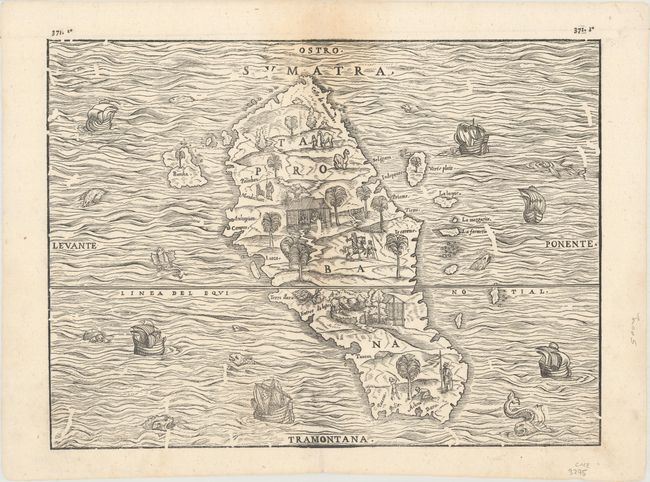
Subject: Sumatra, Indonesia

Period: 1606 (published)

Publication: I Navigatione

Color: Black & White

Size:
14.3 x 10.6 inches
36.3 x 26.9 cm
Download High Resolution Image
(or just click on image to launch the Zoom viewer)

This fine woodcut map of Sumatra (Taprobana) is the first separate map of an Indonesian island to be based on actual empirical data. It is based on the observations of the Parmentier brothers, Frenchmen who ran the Portuguese blockade of the East Indies and landed on the west Sumatran coast. Both brothers died of fever and their crew did not acquire a great deal of wealth, which dissuaded the French from sending further expeditions. Prior to Ramusio's map, Sumatra had been confused with Sri Lanka and maps of the island contained conjectural geography based primarily on Marco Polo. The map is oriented with south at the top and the shape of the island and many of its features are quite accurately portrayed. However, the nearby coastlines of Malaysia and Java are completely missing, although several of the surrounding small islands, such as Bancha (Banca) are shown. Charming scenes in the interior show vegetation, animals, and native figures at work and play, and there are numerous ships and creatures in the sea.

References: Suarez (SEA) p.157, Fig.#77.

Condition: B

Light staining along the centerfold at top. There are a number of small worm/beetle tracks on the woodblock itself that resulted in small areas of missing image. There are no worm tracks on the paper itself, which is still quite supple.

Estimate: $350 - $425

Unsold

Closed on 4/26/2017

Archived