Catalog Archive
Auction 162, Lot 629

Impressive 6-Sheet Wall Map of the Holy Land

"[On 6 joined sheets] Dimidia Tribus Manasse ... [and] Tribus Ruben, et Gad ... [and] Pars Maxima Tribus Iuda ... [and] Tribuum Ephraim ... [and] Tribus Aser ... [and] Tribus Simeon …", Dapper, Olivier
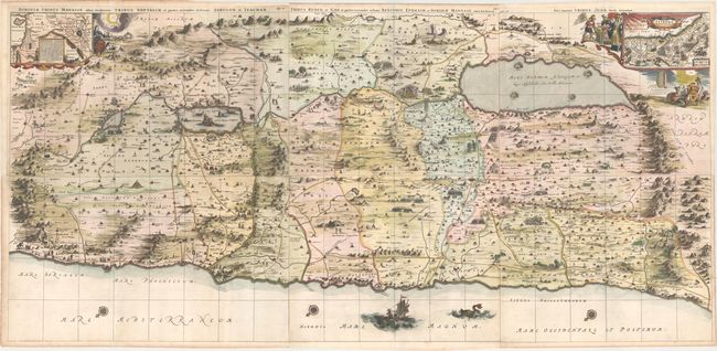
Subject: Holy Land

Period: 1678 (published)

Publication: Naukeurige Beschrijving van Gantsch Syrie, en Palestyn of Heilige Lant

Color: Hand Color

Size:
47.5 x 22.4 inches
120.7 x 56.9 cm
Download High Resolution Image
(or just click on image to launch the Zoom viewer)

This superb, large wall map on six joined sheets is based on Adrichom's "Situs Terrae Promissionis." Oriented to the east, the map shows the region divided into the twelve tribes on both sides of the Jordan River, the shoreline running from Sidon to Alexandria. The Cison Torrens (Kishon River) is shown as connecting the Sea of Galilee with the Mediterranean Sea, and there are many nonexistent rivers, e.g., a river connecting Jerusalem with the Dead Sea. In the Dead Sea, four burning cities are shown: Sodoma, Gomorra, Seboim, and Adama. The dramatic map is beautifully engraved to show topographical features, major roads, towns and villages and richly embellished with dozens of biblical illustrations. Inset maps in the top corners depict Abraham's journey and the wandering of the Israelites through the desert.

References: Laor #233-238.

Condition: A

A crisp impression on watermarked paper with a few short edge tears that enter less than 1" into image that have been professionally repaired. There is light toning along the edges of the sheet.

Estimate: $1,600 - $1,900

Sold for: $1,300

Closed on 4/26/2017

Archived