Catalog Archive
Auction 162, Lot 368

Landmark Map of Florida, Cuba and the Bahamas

"Nieuwe en Naeukeurige Afteekening vant Canaal van Bahama... / Nouvelle Carte Marine du Canal de Bahama...", Keulen, Gerard van

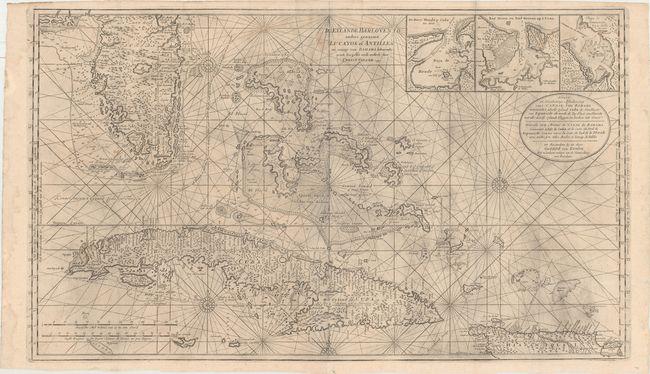
Subject: Florida, Cuba & Bahamas

Period: 1780 (circa)

Publication:

Color: Black & White

Size:
39.8 x 23.2 inches
101.1 x 58.9 cm
Download High Resolution Image
(or just click on image to launch the Zoom viewer)

This superb, large-scale nautical chart is a landmark in the mapping of the Florida peninsula, Bahamas and Cuba. Southern Florida is shown in tremendous detail and includes dozens of place names, islands and soundings with an excellent depiction of the Keys. The fine detail extends throughout the Bahamas and Cuba and includes three inset plans of Havana, Hondo and Matanzas Bays. A note at top refers to the discovery of the Bahamas by Columbus. Van Keulen based much of his map on English observations and included two designations of latitude (English and Dutch) which vary by 30 minutes.

Gerard Van Keulen was the son of Johannes Van Keulen, patriarch of perhaps the most prolific of all Dutch map making families. The family firm commenced in 1680, but it was Gerard who brought it to its full glory in the 18th century. A talented engraver and mathematician, and later Hydrographer to the East India Company, Gerard became the mainspring of the business, issuing many important charts and books on all aspects of geography, navigation, etc. Until the opening of the Dutch Hydrographic Office in the 19th century, the Van Keulen firm issued what were regarded as the official Dutch sea charts.

References:

Condition: B+

A dark impression with some printer's ink residue, a light damp stain at top, and a few small stains adjacent to Florida. A small hole south of Charlotte Harbor has been archivally repaired. Issued folding with a few tiny holes at fold intersections and minor extraneous creases.

Estimate: $5,500 - $6,500

Sold for: $3,250

Closed on 4/26/2017

Archived