Catalog Archive
Auction 162, Lot 27

"The World, with the Latest Discoveries, from the Best Authorities", Lodge, John
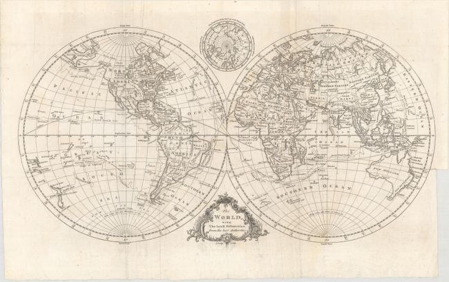
Subject: World

Period: 1778 (published)

Publication: The History of America...

Color: Black & White

Size:
19.9 x 10.9 inches
50.5 x 27.7 cm
Download High Resolution Image
(or just click on image to launch the Zoom viewer)

An attractive, double-hemispheric map of the world. It depicts Virginia, North Carolina, South Carolina and Georgia extending to the Mississippi River, and Florida is divided into East and West. Alaska has an indistinct coastline that extends nearly to Kamchatka with Mt. St. John near the end. A series of rivers and lakes, including a River of the West, are nearly connected from Hudson Bay to the Pacific Ocean, eluding to a possible Northwest Passage. Tasmania is still shown connected to mainland Australia, and the tracks of Cook and Anson are shown throughout the oceans. In the cusp above the map is a smaller hemispheric map featuring the North Polar regions above 50 degrees. Decorated by a rococo-style title cartouche.

The map was published in William Russell's The History of America..., and the original title page is included with the map.

References:

Condition: B+

Issued folding with faint scattered foxing and light extraneous creasing adjacent to the folds.

Estimate: $250 - $325

Unsold

Closed on 4/26/2017

Archived