Catalog Archive
Auction 161, Lot 257

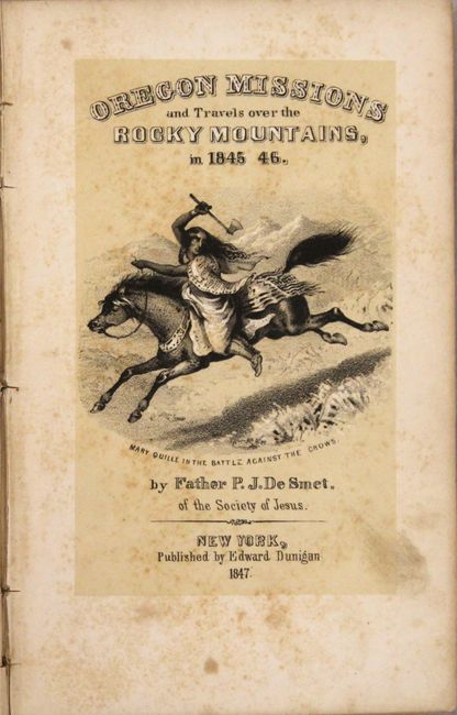
"Oregon Missions and Travels Over the Rocky Mountains, in 1845 46", De Smet, Father Pierre-Jean

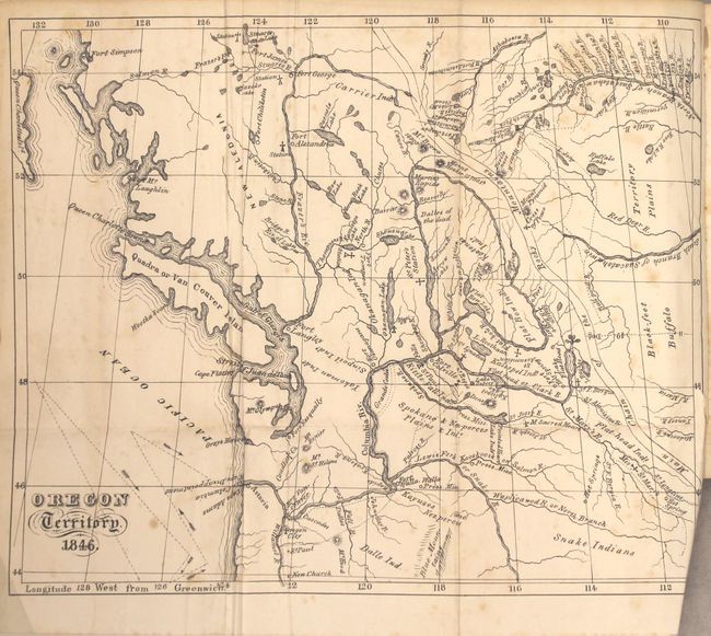
Subject: Northwestern United States

Period: 1847 (published)

Publication:

Color: Black & White

Size:
4.6 x 7.1 inches
11.7 x 18 cm
Download High Resolution Image
(or just click on image to launch the Zoom viewer)

This is the first edition of the highly regarded and rare journal complete with all plates and the folding map (10 x 8.3") Oregon Territory. 1846 his "best known" map per Wheat. The map shows the Pacific Northwest from central Oregon north to beyond Queen Charlotte Island showing Fort Simpson on the mainland. The map extends eastward to well beyond the Rocky Mountains into the plains. Locates numerous Indian lands including those of the Blackfeet adjacent to "Buffalo" in the far plains. Filled with information, locating Oregon City, Fort Walla Walla, Mt. St. Helens, Fort Nasqually, Fort Langley, Dalles of the dead, St. Peter's Station, and many more. The watershed is highly developed with many tributaries to the major rivers named. The Roman Catholic missions and churches are carefully shown, as are the "Press" (Presbyterian) Missions near Walla Walla and on the Salmon River. The "Main Chain of the Rocky Mountains" is delineated with two parallel lines winding through the map. Wheat describes this as "an excellent map and discloses the travels and careful studies made by De Smet, though the main chain of the Rockies still remains vague and undefined."

Includes 12 of the 13 called for plates (missing "The Lodge Pole") plus the illustrated title page "Mary Quille in the Battle Against the Crows," not collated in Wagner & Camp. The plates show chiefs, mounted warriors, teepees, buffaloes and missions. In original blindstamped olive cloth. Hardbound, small octavo, 408 pp. plus 4 pages of "Our Father" translated into various Indian language, plates, and folding map. This first edition was published by Edward Dunigan, New York.

De Smet was one of the earliest and most important missionaries active in the American West. Oregon Territory then consisted largely of the future states of Oregon, Washington, Idaho and the western part of Montana. As described in this book he traveled through parts of Washington, with trips though the Columbia River Plateau country, a trip up the Columbia River to its source and continuing to Fort Augusta through Assinibone territory via the Athabasca River. He returned to Fort Vancouver by way of Fort Colville. He also visited forts Walla Walla, Jasper, and Augustus (Edmonton). Another trip took him on an overland journey to the upper Missouri River, then downstream to St. Louis in 1846. The book naturally focuses on his work as a Catholic priest with emphasis on his efforts to establish relationships with the Indian tribes. Thus the book contains a treasure of ethnological information about the Blackfeet, Flatheads, Coeur d'Alenes, Kalispells, Crows and others. He also made numerous and valuable observations on travel, landscape, and wildlife. Wagner- Camp-Becker were impressed enough with the book to illustrate its title page in their "The Plains and the Rockies," one of only 33 selected to illustrate out of 429 listed.

References: Wagner & Camp #141:1; Wheat (TMW) #535.

Condition: B

The map has light scattered foxing and a few extraneous creases adjacent to the folds. There is a short binding tear at right that just passes the border. Text and plates have light scattered foxing throughout. There is a small library bookplate on the front pastedown and a blind stamp on the title page. The spine has nearly perished but the text block is only a bit loose. Covers are moderately worn and sunned.

Estimate: $650 - $800

Sold for: $425

Closed on 2/8/2017

Archived