Catalog Archive
Auction 161, Lot 141

Matching Set of SDUK Maps

"[Lot of 15 - United States & Canada]", SDUK Society for the Diffusion of Useful Knowledge

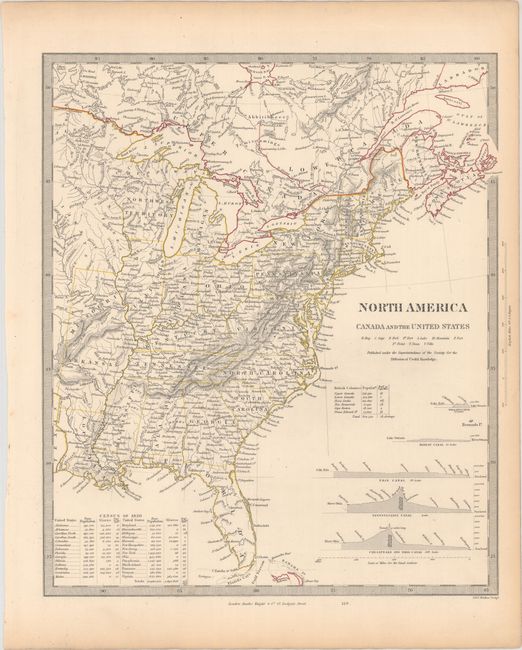
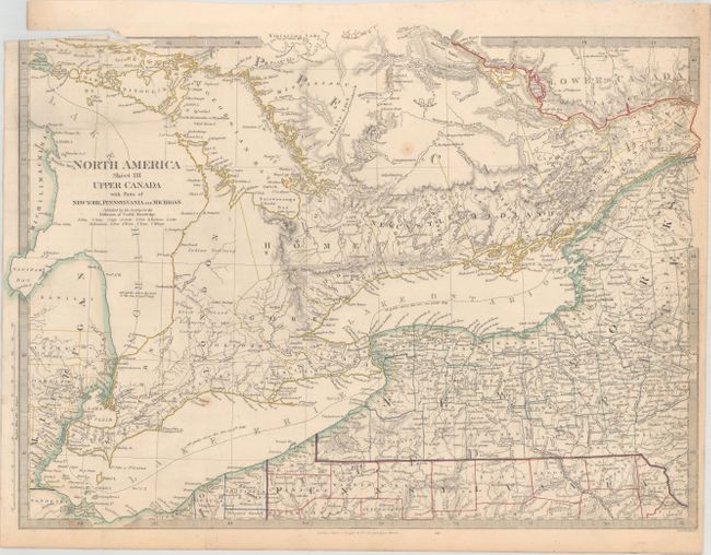
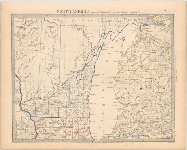
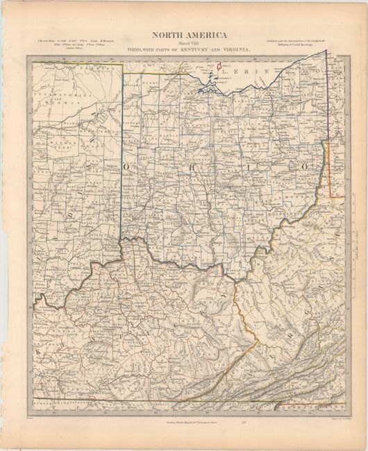
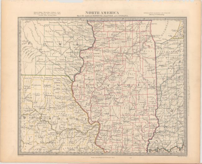
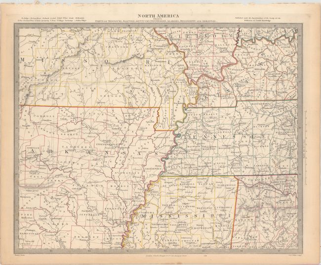
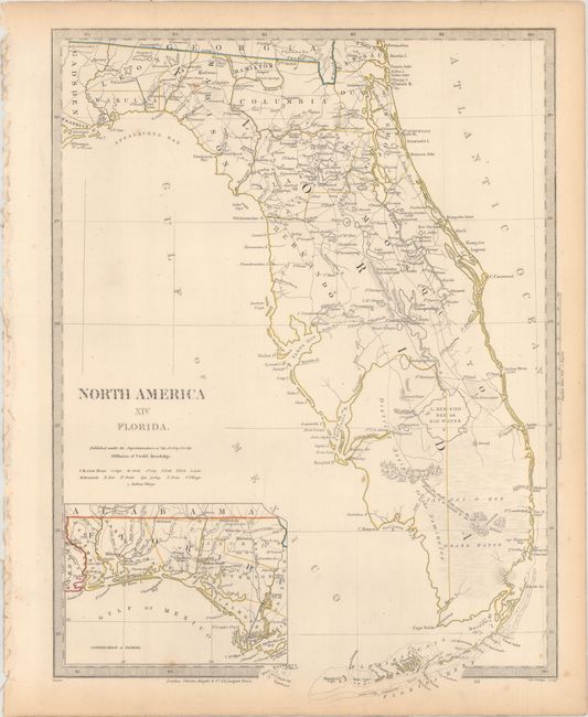
Subject: Eastern United States & Canada

Period: 1835 (circa)

Publication:

Color: Hand Color

Size:
See Description
Download High Resolution Image
(or just click on image to launch the Zoom viewer)

The beginning of the nineteenth century saw a period of rapid market growth and innovation in the map publishing world. Increased literacy and public interest in new frontiers and colonies overwhelmed the market because it was oriented toward the small, affluent market of the previous century. With the intent to fill this void, The Society for the Diffusion of Useful Knowledge (SDUK) was founded in 1828 in London, by Lord Brougham and a group of men dedicated to the education of the aspiring working class and the Utilitarian ideal of 'Knowledge is Power.' The society produced an array of education materials, but the series of maps was one of their most successful ventures. A number of engravers and printers were used to produce the maps, which eventually exceed 200 sheets, and continued to be published after the Society as a whole ceased to function.

This remarkable, complete set of maps covers the eastern United States and Canada. The first map is the index sheet, which identifies the 14 numbered sheets. The index map includes elevation profiles of the Welland, Rideau, Erie, Pennsylvania, and the Chesapeake and Ohio Canals. These important canals formed the transportation network that opened up a connection from the populated Northeast to the Great Lakes and western frontier in the early part of the nineteenth century. An extensive table gives population figures for each state and territory from the Census of 1830. Complete, matching set published by Charles Knight.

A. North America Canada and the United States (12.3 x 14.4").
B. North America Sheet I Nova-Scotia with Part of New Brunswick and Lower Canada (12.4 x 15.5").
C. North America Sheet II Lower-Canada and New Brunswick with Part of New-York, Vermont and Maine (15.5 x 12.9").
D. North America Sheet III Upper Canada with Parts of New York, Pennsylvania, and Michigan (17.4 x 12.7").
E. North America Sheet IV Lake Superior… (15.5 x 11.8").
F. North America Parts of Wisconsin and Michigan. Sheet V (15.2 x 11.9").
G. North America Sheet VI New-York, Vermont, Maine, New-Hampshire, Massachusetts, Connecticut, Rhode-Island, and New-Jersey (12.3 x 13.9").
H. North America Sheet VII Pennsylvania, New Jersey, Maryland, Delaware, Columbia and Part of Virginia (12.9 x 14.8").
I. North America Sheet VIII Ohio, with Parts of Kentucky and Virginia (12.5 x 14.1").
J. North America Sheet IX Parts of Missouri, Illinois and Indiana (14.6 x 11.9").
K. North America Sheet X Parts of Missouri, Illinois, Kentucky, Tennessee, Alabama, Mississippi and Arkansas (15.6 x 12.4").
L. North America Sheet XI Parts of North and South Carolina (13.0 x 14.9").
M. North America Sheet XII, Georgia with Parts of North & South Carolina, Tennessee, Alabama & Florida (12.5 x 15.8").
N. North America Sheet XIII Parts of Louisiana, Arkansas, Mississippi, Alabama & Florida (16.1 x 12.1").
O. North America XIV Florida (12.2 x 16.3").

References:

Condition: B+

Original outline color with a few faint spots of foxing and light toning primarily along sheet edges. Sheet III, which is folding, has a 2.5" binding tear at top (B).

Estimate: $1,000 - $1,300

Sold for: $700

Closed on 2/8/2017

Archived