Catalog Archive
Auction 161, Lot 134

"America Septentrionalis a Domino d'Anville in Galliis Edita nunc in Anglia Coloniis in Interiorem Virginiam Deductis nec non Fluvii Ohio Cursu...", Homann Heirs

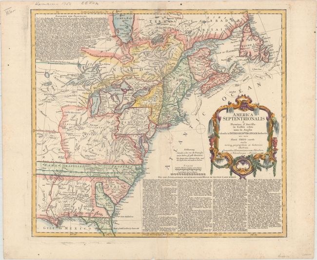
Subject: Colonial Eastern United States & Canada

Period: 1756 (dated)

Publication:

Color: Hand Color

Size:
20.1 x 18 inches
51.1 x 45.7 cm
Download High Resolution Image
(or just click on image to launch the Zoom viewer)

This informative and interesting map of colonial North America from the French and Indian War period shows the area from James Bay and Newfoundland in the north to northern Florida and the Gulf Coast in the south. The map is based on D'Anville's cartography with Jefferys' map of 1755 for the political detail. It shows the British and French possessions from a British point of view. The western extent of the map is just west of the Mississippi River with Virginia, Earl Granvilles Property and North Carolina all extending off the map. The boundary of New York crosses Lakes Ontario, Huron and Erie to include the lower peninsula of Michigan. This map shows a very early Georgia, chartered in 1754. It is embellished with a large rococo cartouche. The extensive text in German, describing the British claims and French encroachments, was taken from Jefferys' map.

References: McCorkle #756.1; Sellers & Van Ee #68.

Condition: B+

On watermarked paper with a light damp stain adjacent to the centerfold, a few minor ink stains, and two tiny holes in the top border only visible when held to light.

Estimate: $600 - $750

Sold for: $375

Closed on 2/8/2017

Archived