Catalog Archive
Auction 161, Lot 131

Reduced Version of De Fer's Influential Map of French Possessions in North America

"Carte de la Nouvelle France, ou se voit le Cours des Grandes Rivieres de S. Laurens & de Mississipi Aujour d'hui S. Louis, aux Environs des-quelles se Trouvent les Etats, Pais, Nations, Peuples &c...", Ottens/De Fer

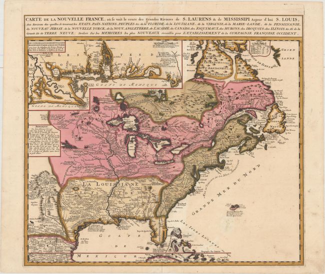
Subject: Colonial Eastern United States & Canada

Period: 1745 (circa)

Publication:

Color: Hand Color

Size:
21.8 x 19.7 inches
55.4 x 50 cm
Download High Resolution Image
(or just click on image to launch the Zoom viewer)

Derived from Nicholas de Fer's important four-sheet map of 1718, this is the most informative map of the French possessions in North America in the early 18th century. It was issued to promote the recently established Compagnie Francoise Occident, which was formed to fund the debt of Louis XIV and offered inducements to encourage settlement in Louisiana. Louisiana and the Mississippi Valley are based on Delisle's manuscript map of 1701, while the geography of New England and eastern Canada originates with Franquelin. Inset at top left is a large-scale map of the Mississippi Delta and Mobile Bay, based on the voyage of Pierre Le Moyne d'Iberville. This smaller version is found in atlases published by Ottens and other Dutch composite atlases. There is no engraver or publisher's imprint.

References: Kershaw #337; McCorkle #719.5.

Condition: B+

Full original color with a few minor spots of foxing. All areas with green pigment have been professionally backed to repair several cracks caused by the oxidation of the green pigment and prevent any future cracking. Three small worm tracks along the centerfold at top and bottom have been professionally infilled, with a very minor amount of text replaced in facsimile.

Estimate: $2,300 - $2,750

Sold for: $1,200

Closed on 2/8/2017

Archived