Catalog Archive
Auction 160, Lot 98

"[A Chart of North and South America, Including the Atlantic and Pacific Oceans, with the Nearest Coasts of Europe, Africa, and Asia - Sheets III and IV]", Jefferys/Sayer & Bennett

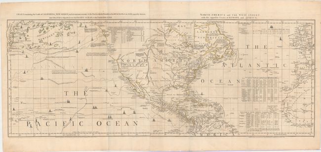
Subject: Colonial North America, North Atlantic & North Pacific Oceans

Period: 1775 (dated)

Publication: The American Atlas

Color: Hand Color

Size:
44.4 x 16.8 inches
112.8 x 42.7 cm
Download High Resolution Image
(or just click on image to launch the Zoom viewer)

Thomas Jefferys was one of the most important English map publishers of the 18th century. His work included prints and maps of locations around the world, but his most notable maps are of North America and the West Indies. He began his career in the map trade in the early 1730s, working as an engraver for a variety of London publishers, and eventually setting up his own shop. In 1746, he was appointed Geographer to the Prince of Wales, and in 1760 he became Geographer to the King. These titles granted access to manuscripts and cartographic information held by the government. In the early 1760s he embarked on an ambitious project to produce a series of English county maps based on new surveys, but ran out of money and filed for bankruptcy in 1766. He then partnered with London publisher Robert Sayer, who reissued many of Jefferys plates and continued to issue new editions after Jefferys' death in 1771. Jefferys' American Atlas and the accompanying West-India Atlas, published post posthumously, are considered his most important cartographic works.

This is sheet III and IV of a six-sheet map of the western hemisphere known as one of the most important American maps of the latter part of the eighteenth century. The map was compiled in 1753 by Braddock Meade, one of the most intriguing figures in British cartographic history as well as an extremely gifted mapmaker. Working under the alias John Green after serving time for defrauding an Irish heiress, he compiled many of Thomas Jefferys' most important maps. Meade's six-sheet map was created just prior to the
French and Indian War
and depicted the extent of the various colonial possessions. In addition, the map was also designed to expose the errors in Delisle and Buache’s map of the Pacific Northwest and was the first map to label the Bering Strait. Of particular interest on the map are the tables of charts that show the variations in latitude and longitude between this chart and those of Bellin, D'Anville, and Popple. There are numerous notations throughout the map that present a fascinating view of the state of geographic knowledge of the period. Each of the six sheets were given full borders and their own title, so that they could be sold separately, joined horizontally in pairs and bound into the atlas, or combined into a large wall map.

This lot contains the central two sheets, joined, and each separately titled: Chart, Containing the Coasts of California, New Albion, and Russian Discoveries to the North; with the Peninsula of Kamtschatka, in Asia... [and] North America and the West Indies, with the Opposite Coasts of Europe and Africa. The sheets depict North America flanked by the North Pacific and North Atlantic Oceans, extending west to the Kamchatka Peninsula, and east to show parts of Europe and Africa. The tracks of numerous ships criss-cross the oceans along with notations of the various explorers. In North America, the boundaries of Virginia, North Carolina, South Carolina, and Georgia are open-ended to the west, and Florida is divided into East and West. There are numerous Indian tribes located throughout. In northern Quebec is a New Discovered Sea, which was soon thereafter proven to be a cartographic error, and two different Rivers of the West appear in the Pacific Northwest. This is the fourth state, published by R. Sayer & J. Bennett, and dated 10 June 1775.

Jefferys was the leading English cartographer of the 18th century, serving as both Geographer to the Prince of Wales, and later, Geographer to the King, he had access to the best surveys conducted in America. He published a series of maps of the American colonies that were among the most significant produced in the period, including the Fry/Jefferson map of Virginia, Braddock Meade’s map of New England, and William Scull’s map of Pennsylvania and the western frontier. His successors, Sayer and Bennett, gathered these separately-issued maps together and republished them as The American Atlas. "It was, very likely, consulted by American, English, and French civilian administrators and military officers during the Revolution." (Ristow)

References: Ristow pp. 31-32; Schwartz & Erhrenberg, p.158-59; Stevens & Tree #4-Sheet III & IV (d); Wagner (NW) #578 & p. 160 (1st ed.).

Condition: B+

Original outline color on heavy paper with a Strasbourg Lily watermark. There are a few small worm holes, light offsetting, and a mis-fold at left. There are old paper repairs to a centerfold separation that enters 1" into map at bottom right, as well as to two tears that enter 1" into map at each side.

Estimate: $1,500 - $1,800

Sold for: $1,000

Closed on 11/16/2016

Archived