Catalog Archive
Auction 160, Lot 8

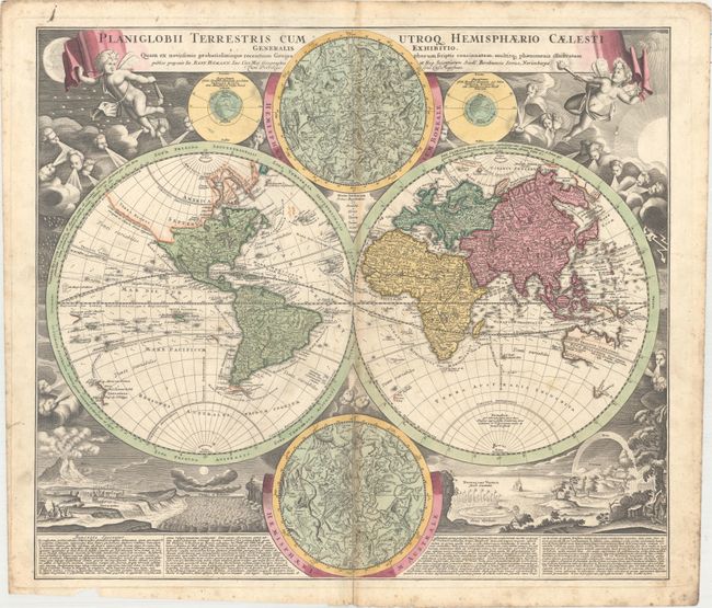
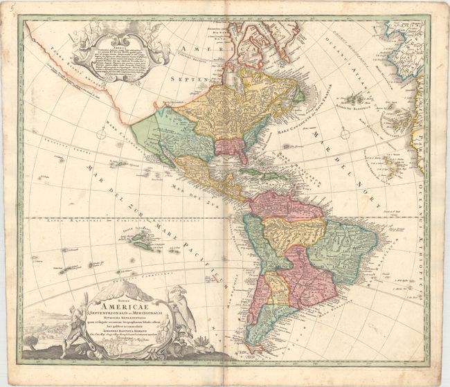
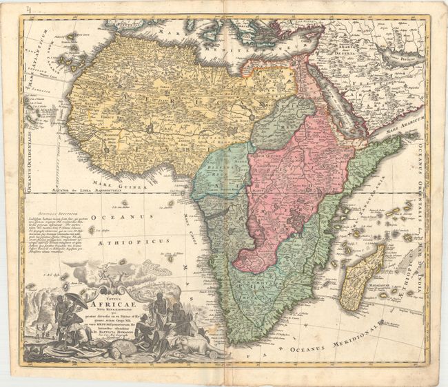
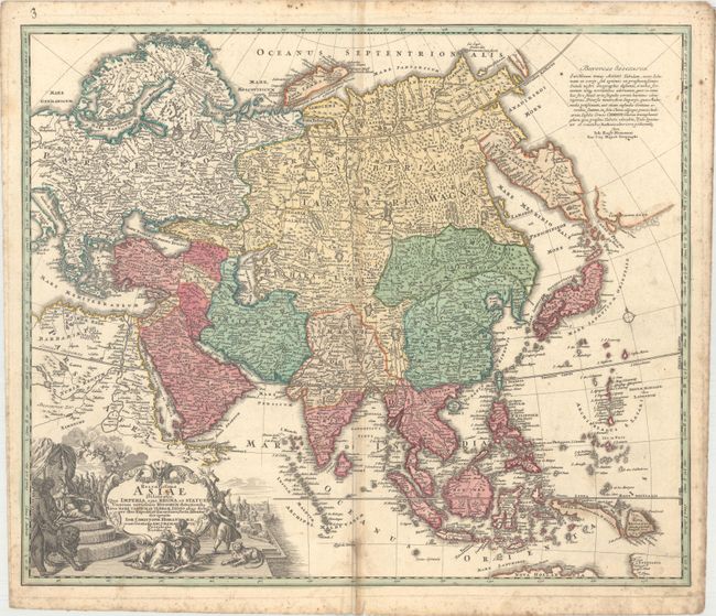
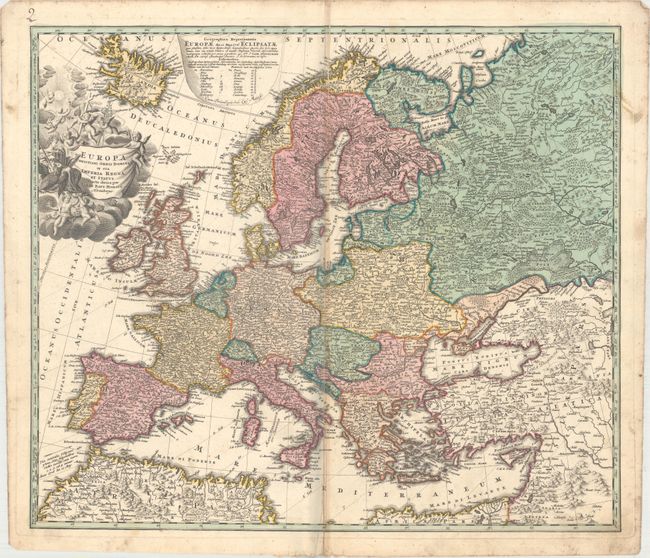
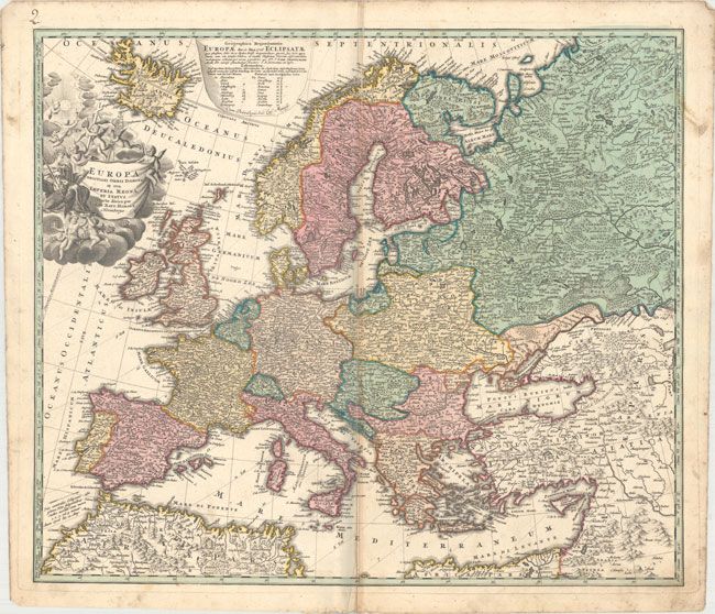
Homann's World & Continents Set in Full Original Color

"[Lot of 5] Planiglobii Terrestris cum Utroq Hemisphaerio Caelesti... [and] Totius Americae Septentrionalis et Meridionalis... [and] Totius Africae Nova Representatio... [and] Recentissima Asiae Delineatio... [and] Europa Christiani Orbis Domina...", Homann, Johann Baptist

Subject: World & Continents

Period: 1730 (circa)

Publication:

Color: Hand Color

Size:
21.9 x 19.1 inches
55.6 x 48.5 cm
Download High Resolution Image
(or just click on image to launch the Zoom viewer)

An attractive matched set from a composite atlas. Size varies slightly.

A. Planiglobii Terrestris cum Utroq Hemisphaerio Caelesti Generalis Exhibitio.... This is one of the most decorative eighteenth century world maps. The two hemispheres are surrounded by vivid engravings of natural phenomena such as a rainbow, earthquakes, and a volcano. Wind heads occupy the starry heavens, and two putti hold the title banner aloft. The map itself shows a typical geographical view of the period. An indistinct Terra Esonis appears above California, here depicted as a peninsula. The partial coastlines of Australia, New Zealand, and New Guinea are noted. Australia is shown to be separate from New Guinea, Carpentaria and Van Diemen's Land. Nova Britannia is shown as a separate island off the coast of New Guinea with the notation that it was discovered by Dampier in 1700. Several explorer's tracks are traced, including Magellan, Dampier, Tasman, Gaetani and Charmont. Nestled between the hemispheres are two detailed celestial maps. Text panels at bottom describe the natural phenomena. A key in the lower margin explains the color coding, which divides the world into various religious sects. Homann borrowed both the cartography and depictions of natural phenomenon from Zurner's similar map circa 1700. Condition: There is a 6" separation at bottom that has been archivally closed on verso. Light soiling with scattered foxing primarily in the blank margins.

B. Totius Americae Septentrionalis et Meridionalis Novissima Repraesentatio.... This attractive map is a revision of the elder Homann's 1710 map of the Americas. After his death in 1724, his son (Johann Christoph Homann) re-engraved the plate to correct the western coastline of North America, shown here extending very far west and north, with very little detail. California is no longer shown as an island, although the remnants of the interior sea can be seen near the Pais de Moozemleck where a river nearly connects with the Mississippi River system, hinting at the possibility of a Northwest Passage. The Great Lakes are taking shape, being actively explored by the French fur traders and the Hudson Bay Company. The Solomon Islands are prominently placed in the Pacific, considerably too far to the east. The map is decorated with two large pictorial cartouches, the one at top shows natives worshiping a fearsome demon at the right, while at left they listen placidly to a priest. The lower cartouche also features the landscape and native fauna. References: McLaughlin #175; Tooley (Amer) p. 129 #79; Portinaro & Knirsch #109. Condition: There is light soiling with a 3" separation at bottom that has been archivally closed on verso.

C. Totius Africae Nova Representatio.... Handsome, large map of the continent with the typical inaccuracies of eighteenth century cartography. The map conforms to the twin lake configuration for the source of the Nile and a lengthy paragraph on the map purports to provide evidence of the accuracy of this theory based on the work of Heinrich Scherer. The geographical features are identical to the map that Johann engraved for Jacob von Sandrart, circa 1697, prior to Homann establishing his own publishing firm. The political boundaries and the large title cartouche are different. The cartouche is filled with interesting imagery including the pyramids, ivory trading, the source of the Nile, a troop of monkeys (throwing rocks at their hunters), kings, chiefs and warriors, a fat-tailed sheep with its tail supported by a wagon, and cherubs bringing salvation to the continent. Reference: Norwich #72. Condition: There are several small stains at bottom with a 2.5" separation at bottom closed on verso with archival material and a short open separation at top.

D. Recentissima Asiae Delineatio.... This map is a revision of the elder Homann's map of Asia circa 1712. The most important innovation is the addition of a huge Kamchatka Peninsula labeled Kamtzadalia Sinis Jeso with the southern tip marked Kurilorum Regio - an early reference to the Kuril Islands. Japan is separated from the Kamchatka Peninsula by a cluster of smaller islands. East of this archipelago, and separated from it by a narrow strait identified as the Canal de Piecko, is a coastline of Campagnie Land. Another notable difference is the depiction of the Caspian Sea based on the 1722 surveys of Karl van Verden. In Southeast Asia the straits between New Guinea and Australia still appear in a tentative fashion, noting Dampier's Strait and a disembodied Carpenteria with no definite northern limit. The map is decorated with the same title cartouche as the elder Homann's map, featuring an Asian queen holding court, but the upper cartouche has been replaced with a simple block of text. Reference: Yeo #123. Condition: There is light soiling and scattered foxing mostly in the blank margins.

E. Europa Christiani Orbis Domina in sua Imperia Regna.... An attractive early 18th century map by this important German cartographer. The map illustrates the Christian kingdoms in Europe and is characteristically filled with details, even for such a general map. The large title cartouche features a personification of Europa surrounded by adorable putti nestled in the clouds. Condition: There is an 8" fold separation at bottom that has been archivally repaired on verso, a printer's crease adjacent to the centerfold at top, and minor soiling mostly in the blank margins.

References:

Condition: B

Full original color on watermarked sheets with light toning along the centerfolds. See description above for details.

Estimate: $4,000 - $5,000

Unsold

Closed on 11/16/2016

Archived