Catalog Archive
Auction 159, Lot 207

Second State of Purcell's Map Locating the Proposed State of Frankland

"A Map of the States of Virginia North Carolina South Carolina and Georgia Comprehending the Spanish Provinces of East and West Florida Exhibiting the Boundaries Between the United States and Spanish Dominions...", Purcell, Joseph

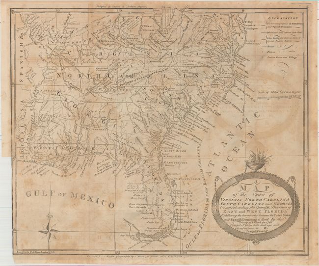
Subject: Southern United States

Period: 1793 (published)

Publication: Morse's American Universal Geography

Color: Black & White

Size:
14.9 x 12.7 inches
37.8 x 32.3 cm
Download High Resolution Image
(or just click on image to launch the Zoom viewer)

This fine map is a fascinating historical document of the United States following the Revolutionary War. It includes an early reference to the Country of Frankland in present-day eastern Tennessee. The map includes a great amount of information including boundaries claimed by the various Indian Nations and trading paths on the western frontier. It shows early settlements, including a Moravian Settlement in North Carolina, and the Cumberland Settlements in Tennessee. At the top of the map, in the nascent Northwest Territory, the 7 Ranges denote the first application of the Public Land Survey System. Several bounty land grants are shown including the Ohio Company, Wabash Company, New Jersey Company and Illinois Company and the Donation Lands of the Commonwealth of Virginia. A triangular shaped plot of land in the region of present-day West Virginia is labeled Indiana. This is the second state with the date erased from the New Haven imprint of Amos Doolittle at bottom and the addition of the Boston imprint of Thomas and Andrews at top.

In 1785, settlers in present-day western North Carolina and eastern Tennessee organized a state government to be named in honor of Benjamin Franklin, Franklinia or Frankland. Congress turned down their appeal but the state maintained a legislature and governor until 1788. This ephemeral state appeared on a small number of maps into the early part of the 19th century.

The Revolutionary government of the United States used bounty land grants in their struggle for independence from Great Britain. The free lands exchanged for military service provided an effective technique for enrolling support for the war and encouraging re-enlistments. Generally the bounty lands were located on the western frontier, which provided another benefit to the government. Populating the frontier with citizens skilled in defense offered the best prospect in enticing other settlers to join them, thus eventually increasing the tax rolls.

The region shown on this map as Indiana was originally granted to a Philadelphia trading company by the Iroquois Confederacy in 1768. Then in 1776 it was sold to the Indiana Land Company, but was also claimed by the State of Virginia as a part of her original charter. The resulting battle between the private land company and Virginia resulted in the Eleventh Amendment to the U.S. Constitution and is one of the most interesting chapters in the history of the young United States.

References: Dotson (Franklin Maps) #3A; Baynton-Williams (TMC-72) p. 15, #2.i; Sellers & Van Ee #1410; Wheat & Brun #494.

Condition: B

Issued folding with moderate offsetting. There is a binding trim at lower left and an associated 4" binding tear as well as a short fold separation that have been repaired on verso with archival tape.

Estimate: $800 - $1,000

Sold for: $800

Closed on 9/14/2016

Archived