Catalog Archive
Auction 159, Lot 108

"Carte du Mexique et de la Floride des Terres Angloises et des Isles Antilles. Du Cours et des Environs de la Riviere de Mississipi...", Delisle/Covens & Mortier

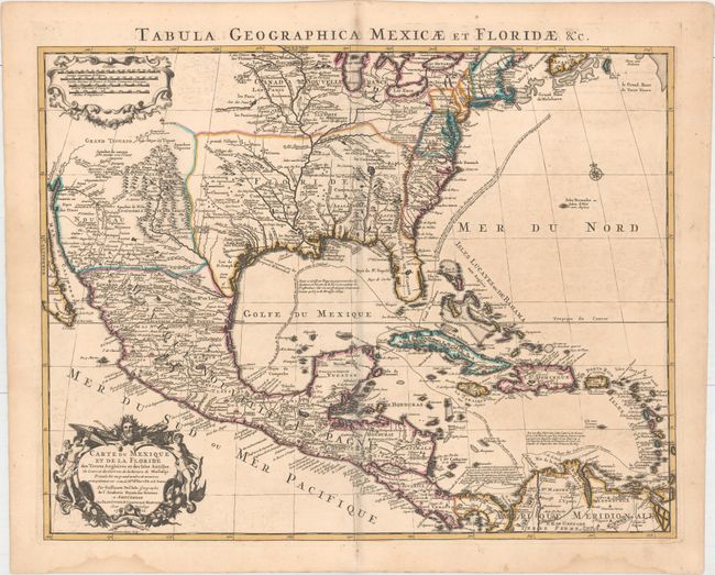
Subject: Colonial Eastern North America & West Indies

Period: 1722 (dated)

Publication: Atlas Nouveau

Color: Hand Color

Size:
23.5 x 18.4 inches
59.7 x 46.7 cm
Download High Resolution Image
(or just click on image to launch the Zoom viewer)

Covens & Mortier's issue of Delisle's important map that is credited with accurately showing the course of the Mississippi River and its mouth for the first time. The map influenced later delineations of the Mississippi River by Seutter, Homann, Lotter and others for many years. It is an attractive map that includes much of the present day United States, Mexico, Central America, and the Caribbean. The British colonies are confined along the eastern seaboard. Florida is shown as a Spanish possession taking in the entire southern region and the Southwest is labeled Nouveau Mexique. This issue has the route of the Spanish galleons added, and the title in Latin along the top margin.

References: Tooley (Amer) #51; Schwartz & Ehrenberg, plt. 82; cf Cummings (SE) #137; Martin & Martin plt.17.

Condition: B+

A dark impression on watermarked paper with light offsetting, faint toning along the centerfold, and light damp stains confined to the bottom blank margin.

Estimate: $1,200 - $1,500

Unsold

Closed on 9/14/2016

Archived