Catalog Archive
Auction 158, Lot 88

Important Map of Colonial New England and the Mid-Atlantic in Full Original Color

"Nova Belgica et Anglia Nova", Blaeu, Willem

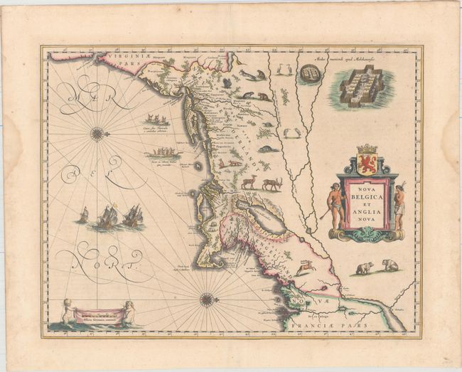
Subject: Colonial New England & Mid-Atlantic United States

Period: 1640 (circa)

Publication:

Color: Hand Color

Size:
19.9 x 15.3 inches
50.5 x 38.9 cm
Download High Resolution Image
(or just click on image to launch the Zoom viewer)

This important map, first issued in 1635, is one of the first to focus on the Dutch colony in North America and to name Nieu Amsterdam (New York). It is based on the manuscript of Andriaen Block (1614), a Dutch fur trader, who explored the area between Cape Cod and Manhattan and was the first to correctly delineate the longitudinal scale of the coastline and establish Manhattan as an island. The colony of Nieu Pleimonth is identified, as well as other English names along the coast, which were derived from Smith's map of New England in 1616. The map is oriented with north to the right and is richly adorned with a variety of wildlife, including the first appearance of beavers, polecats and otters on a printed map. Quebec is noted with a minute depiction of the fort and buildings, and the mythical kingdom pf Norumbega is noted near the R. Pentagouet (Penobscot River) in present-day Maine. A large Mohawk village is shown derived from the White-de Bry engravings. It is further embellished with a large title cartouche flanked by two natives, sailing ships, canoes, and compass roses. Latin text on verso, published between 1640-55.

References: Burden #241; Goss (Blaeu) p. 164; McCorkle #635.1; Van der Krogt (Vol. II) #9310:2.

Condition: B+

Original color on watermarked paper with minor foxing and faint show through of text on verso. Two damp stains are confined to the left and right blank margins, well away from map. Very nearly in "A" condition.

Estimate: $2,750 - $3,500

Unsold

Closed on 6/22/2016

Archived