Catalog Archive
Auction 158, Lot 421

Extremely Rare Variant of Thevet Map of Africa

"Table d'Afrique", Thevet, Andre
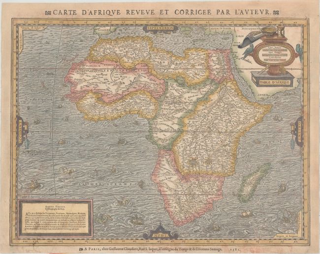
Subject: Africa

Period: 1581 (dated)

Publication: La Cosmographie Universelle

Color: Hand Color

Size:
17.8 x 13.7 inches
45.2 x 34.8 cm
Download High Resolution Image
(or just click on image to launch the Zoom viewer)

This elaborate and decorative map of Africa was created by Andre Thevet, a Franciscan monk who was known to have traveled extensively throughout Europe, the near East, and North Africa. He was Royal Cosmographer to the French kings and is best known for his four continent maps published in La Cosmographie Universelle. This map is important in the evolution of the mapping of Africa, being the first folio-sized map to show the continent modeled after the work of Mercator, and not the Gastaldi-Ortelius model. The map is based on Mercator's world map of 1569, depicting a large lake southwest of the twin lakes indicated by Ptolemy as the sources of the Nile. This large, unnamed lake appears to be the source for several rivers, including the Cuama, Spirito Santo, and Congo Rivers. A number of place names fill the map, with several blank areas marked as deserts. The surrounding waters are teeming with various sailing vessels and sea monsters. The decorative title cartouche features parrots, a partially-rolled sea chart, a compass, and an hourglass. An additional French title appears above the map: "Carte d'Afrique Reveve et Corrigee par l'Auteur." This map appeared in three editions of La Cosmographie Universelle, the first two in 1575, published by Pierre l'Huilier and Guillaume Chaudiere. The third edition was published in 1581 by Guillaume Chaudiere, with the addition of his imprint and the date below the map, as appears on this example. This third edition is extremely rare and only known in a handful of examples.

References: Betz #17, Variant A; Norwich #12.

Condition: B

A nice impression on watermarked paper with light soiling, one small hole at bottom right, and two long tears in the Atlantic that have been professionally repaired. Professionally remargined at left, right, and top with the top half of the title above the map skillfully replaced in facsimile.

Estimate: $2,000 - $2,400

Sold for: $1,500

Closed on 6/22/2016

Archived