Catalog Archive
Auction 158, Lot 14

Apianus' Popular Cordiform World Map from the First Woodblock

"Typus Universalis Terrae, Iuxta Modernorum Distinctionem et Extensionem per Regna et Provincias", Apianus, Peter Bienewitz
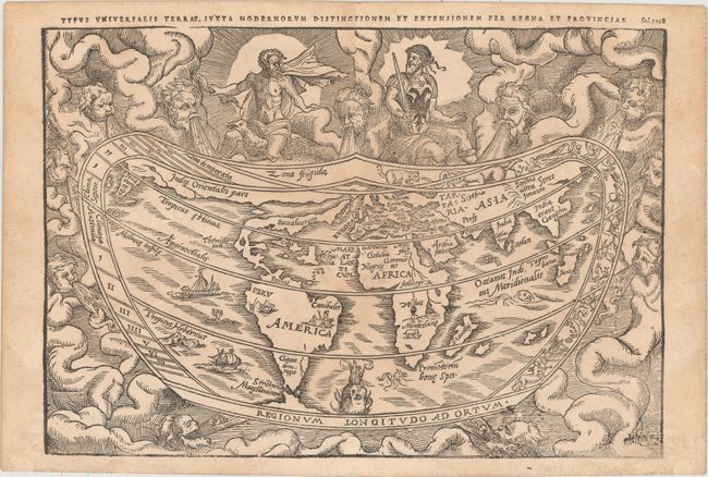
Subject: World

Period: 1583 (published)

Publication: Margarita Philosophica

Color: Black & White

Size:
11 x 7.6 inches
27.9 x 19.3 cm
Download High Resolution Image
(or just click on image to launch the Zoom viewer)

This early map is based on the now lost world map of Gemma Frisius [1540], which is significant in the history of the mapping of America. The continents are broadly based on Mercator's globe gores of 1541, but North America is shown as a long slender landmass labeled Baccalearium in reference to the cod fishing region off the coasts of New England and Canada. It employs a cordiform projection and depicts a distinct northern passage to Asia over the top of North America. In Asia, India and Sri Lanka (Seylan) are noted, in addition to part of Southeast Asia with Sumatra noted as Taprobana. The interior of South America features the notations of Canibales near Brazil and Gigantium regio in the southern tip. Africa has few interior details noted other than the prominent twin lake sources of the Nile, with a note of the Monteslune (Mountains of the Moon) and a lone elephant. The heart-shaped border of the map contains signs of the zodiac within a cloud background filled with mythical figures and wind heads. One of the deities at top sports the design of the Holy Roman Emperor's double eagle on his breastplate, likely in homage to the Emperor Charles V. In contrast, three cadaverous wind heads at bottom represent plague-carrying winds of the south. This example was printed from the first of three woodblocks and was published in Basle in Reisch's Margarita Philosophica.

References: Shirley #82.

Condition: B+

A good impression that is faint at far bottom right with minor toning and soiling.

Estimate: $4,000 - $5,000

Sold for: $2,750

Closed on 6/22/2016

Archived