Catalog Archive
Auction 158, Lot 128

Very Rare - The First Printed Plan of Washington

"Plan of the City of Washington", Thackara, James

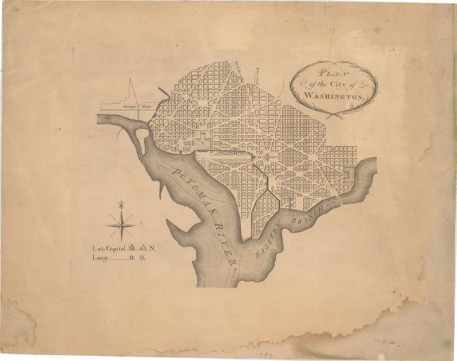
Subject: Washington, D.C.

Period: 1792 (published)

Publication: The Universal Asylum and Columbia Magazine

Color: Black & White

Size:
10.4 x 8.5 inches
26.4 x 21.6 cm
Download High Resolution Image
(or just click on image to launch the Zoom viewer)

This is the first publication of Andrew Ellicott's version of Pierre L'Enfant's plan of Washington, beating out a smaller plan by Samuel Hill that was published two months later. It was issued in the March 1792 edition of The Universal Asylum and Columbia Magazine and also found in Tobias Lear's Observations on the River Potomack in 1793 and 1794. In November of the same year, Thackara & Vallance would issue a second, larger plan which is known as the "official plan." This small plan shows the layout of streets including the long diagonals, but no block numbering. Washington is bordered by the Potomak (Potomac) River and the Eastern Branch, now the Anacostia River. The proposed landscape design for the Mall is shown with only the Capitol and the Presidents House labeled. Unlike later editions, this version does not include soundings in the Potomac River, and there is no block detail in Georgetown. Decorated by an eight-point compass rose with a note indicating longitude of zero, designating Washington as the site of the prime meridian. A cornerstone map for any Washington DC collector.

References: Baynton-Williams, “Plans of Washington, D.C.”, MapForum.com, Issue 12, Map 1; Wheat & Brun #527.

Condition: B

Uniform light toning with damp stains confined to the blank margins. Backed with old linen.

Estimate: $5,000 - $6,500

Sold for: $3,750

Closed on 6/22/2016

Archived