Catalog Archive
Auction 157, Lot 99

A Significant Atlas of the American Revolution

"[Disbound] The American Military Pocket Atlas; Being an Approved Collection of Correct Maps, Both General and Particular, of the British Colonies; Especially Those Which Now Are, or Probably May Be the Theatre of War...", Sayer & Bennett

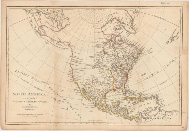
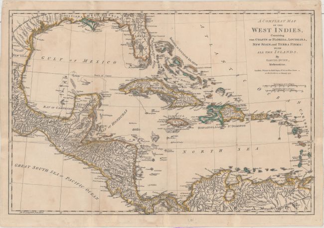
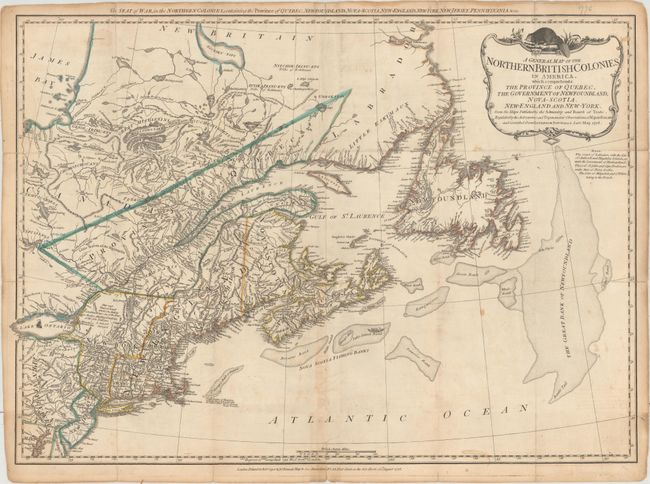
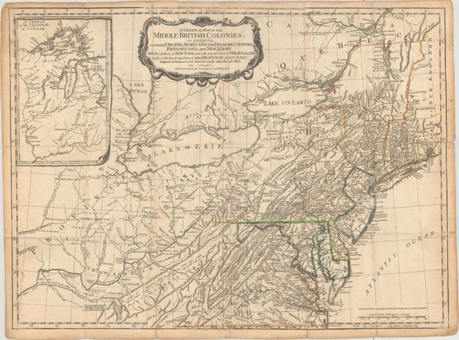
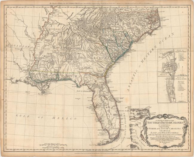
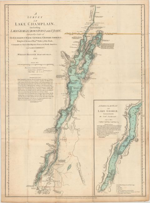
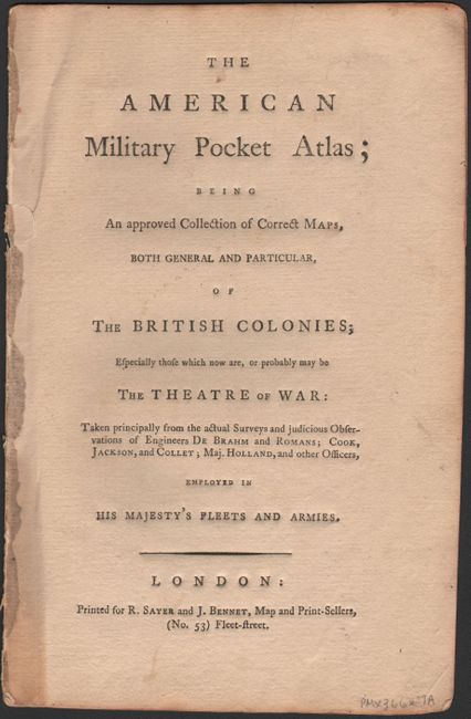
Subject: North America

Period: 1776 (published)

Publication:

Color: Hand Color

Size:
See Description
Download High Resolution Image
(or just click on image to launch the Zoom viewer)

A significant atlas of the American Revolution. It was issued by the British Army to its field officers and was regarded to contain the essential topographical information necessary for the conduct of the war. The large and important maps folded into an octavo volume that could easily be carried into combat, thus it became known as "the Holster Atlas." The title continues: "Taken principally from the actual surveys and judicious observations of engineers De Brahm and Romans; Cook, Jackson, and Collett; Maj. Holland, and other officers, Employed in His Majesty's Fleets and Armies." Printed for R. Sayer and J. Bennett, Map and Print-Sellers, No. 53, Fleet Street, London. The six maps contained the most up-to-date information and provide a graphic view of American geography at the outbreak of the Revolution. The maps include:

A. North America, as Divided Amongst the European Powers, by Samuel Dunn, dated 1774 (17.5 x 12.0"). This map details North America just prior to the start of the Revolutionary War. The map notes various explorations along the West Coast, including those of Sr. Francis Drake, Juan De La Fuca, Tchirikow, and the Land which is supposed to be the Fousang of the Chinese Geographers. Alaska reaches nearly to Kamchatka with Mt. St. John near its westernmost extent. The area is labeled as Discoveries made by the Russians, during the last twenty Years. The mythical River of the West is a long dotted line that connects Aguilar's entrance north of San Francisco Bay (here called Drake's Harbor) with a river system below Lake Winnipeg. Several Indian tribes are located and major cities are named. Texas is here called New Leon.

B. A Compleat Map of the West Indies, Containing the Coasts of Florida, Louisiana, New Spain, and Terra Firma: with All the Islands, by Samuel Dunn, dated 1774 (17.8 x 11.9"). The map shows information on coastal features and limited interior detail including watershed and larger towns. It extends to include an interesting depiction of Florida and south to show the northern portion of South America. The area of today's Belize is labeled Logwood Cutters referring to the British cutting of logwood, greatly valued in Europe as the principal dyestuff for the expanding wool industry.

C. A General Map of the Northern British Colonies in America. Which Comprehends the Province of Quebec, the Government of Newfoundland, Nova-Scotia, New-England and New-York..., dated 1776 (26.3 x 18.8"). This map extends from Maryland and New Jersey in the south to the James Bay and Labrador in the north. The beaver-hunting region east of Lake Ontario is noted as "not yet surveyed." Several Eskimo tribes are noted in the north, and the fishing banks off the coast are well detailed.

D. A General Map of the Middle British Colonies, in America. Containing Virginia, Maryland, the Delaware Counties, Pennsylvania and New Jersey..., dated 1776 (26.1 x 19.2"). This is a later derivative of the seminal Lewis Evans map of the Middle British Colonies, which was one of the landmarks of American cartography. It has been updated to illustrate the Seat of War at the outbreak of the American Revolution from Governor Pownall's map of the same year. The map covers the region from Montreal and the lower end of Lake Huron to the North Carolina border, and from the Falls of the Ohio to Narragansett Bay, with an inset Sketch of the Upper Parts of Canada (Illinois Country). This map was an invaluable resource during the war and is filled with incredibly detailed information including provincial boundaries, courthouses, roads, trails, Indian villages and territories, forts, swamps, mines, portages, and distances between towns.

E. A General Map of the Southern British Colonies, in America. Comprehending North and South Carolina, Georgia, East and West Florida, with the Neighbouring Indian Countries..., by B. Romans, dated 1776 (25.1 x 19.6"). This map extends from North Carolina to Florida, and west past the Mississippi River. Florida is divided into East and West and the names of numerous Native American tribes are located throughout. Two insets depict city plans of Charleston and St. Augustine.

F. A Survey of Lake Champlain, Including Lake George, Crown Point and St. John... by William Brassier, dated 1776 (18.8 x 25.9"). This was the first separately published map to focus on Lake Champlain and Lake George, a strategic link between the St. Lawrence and Hudson Rivers. The map is based on a survey by William Brassier and Dietrich Brehm conducted in 1758-59.

This example is disbound and includes the original title page, introduction and dedication to Gov. Pownall, list of maps, and six maps, all of which are housed in a cardstock portfolio.

References: Howes #A-208; Nebenzahl (Amer. Rev.) pp. 11-17; Sabin #1147; Schwartz & Ehrenberg, p. 190.

Condition: B+

All maps are issued folding, now flattened, with original outline color on watermarked paper. There is minor soiling and offsetting, as well as light toning along one fold on each map where the binder's stub was attached. Most of the maps have a few short fold separations that have been closed on verso with archival material. The map of the Middle British Colonies also has a 2" tear from Rhode Island to New Hampshire that has not been repaired. The text is near fine with minor toning along the edges.

Estimate: $10,000 - $12,000

Sold for: $6,500

Closed on 5/4/2016

Archived