Catalog Archive
Auction 157, Lot 651

First Printed Map to Focus on China and Japan

"[Title on Verso] Tabula Superioris Indiae & Tartariae Maioris", Ptolemy/Fries

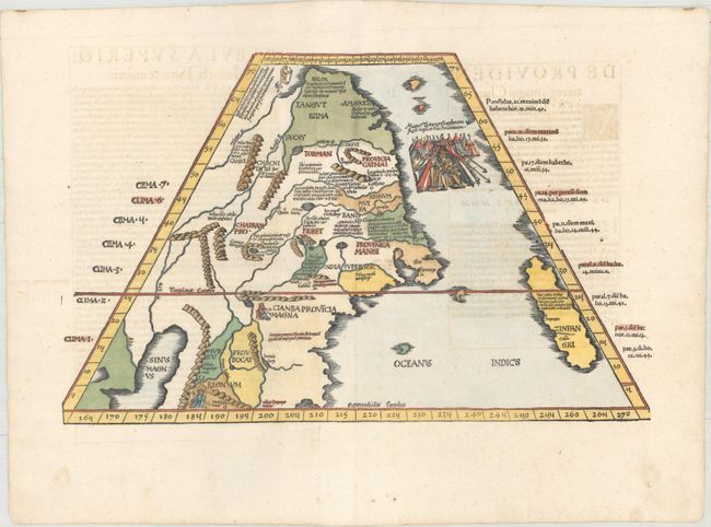
Subject: China, Korea & Japan

Period: 1541 (published)

Publication: Claudii Ptolemaei Alexandrini Geographicae…

Color: Hand Color

Size:
18.2 x 11.4 inches
46.2 x 29 cm
Download High Resolution Image
(or just click on image to launch the Zoom viewer)

Claudius Ptolemy was a mathematician, astronomer and geographer who worked in Alexandria, then a part of the Roman Empire, in the 2nd century AD. One of the most learned and influential men of his time, his theories dominated both astronomy and geography for nearly 1500 years. His writings were kept alive by Arabic scholars during the Middle Ages and reemerged in Europe during the Renaissance. The birth of printing led to wide dissemination of his great works on astronomy and geography. There were a number of editions of his Geographia beginning in 1477. These early editions contained maps based on his original writings, known as Ptolemaic maps. As geographic knowledge increased with the explorations of Columbus, Magellan, Cabot and others, maps of the New World were added, and maps of the Old World were revised. Ptolemy's Geographia continued to be revised and published by some of the most important cartographers including Martin Waldseemuller, Sebastian Munster, Giacomo Gastaldi, Jodocus Hondius, and Gerard Mercator (whose last edition was published in 1730).

This important map is the first printed map to focus on China and Japan. Presented on a trapezoidal projection in Ptolemaic format, the map extends well beyond the geography described by Ptolemy and draws from the report of Marco Polo. Japan (Zinpangri) is a north-south oriented island. Several regions in China are noted with numerous rivers and a huge lake labeled Sinis Magnus. A vignette of the king of Tartary in his tent embellishes the map. This edition was printed by Gaspar Treschel and edited by Michael Villanovus (known as Servetus). Servetus was charged with heresy by John Calvin in 1553, in part due to the text in this atlas. The courts found him guilty and sentenced him to burning at the stake, atop a pyre of his own books, including this atlas.

References: Mickwitz & Miekkavaara #211-43; Walter plt.3.

Condition: B+

A nice impression on paper with a bunch of grapes watermark, several minor professional repairs along the centerfold, and a couple of small holes just to the right of center. There is light show-through of text on verso.

Estimate: $3,000 - $4,000

Unsold

Closed on 5/4/2016

Archived