Catalog Archive
Auction 157, Lot 432

Rare Map by Benjamin Franklin

"Chart of the Gulf Stream", Franklin, Benjamin

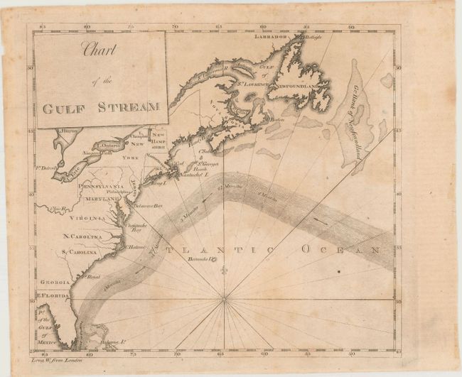
Subject: North Atlantic

Period: 1789 (circa)

Publication: The American Museum...

Color: Black & White

Size:
8.1 x 7.3 inches
20.6 x 18.5 cm
Download High Resolution Image
(or just click on image to launch the Zoom viewer)

This is an updated plate of Benjamin Franklin's groundbreaking chart of the Gulf Stream. The chart was intended to spur sea captains to alter their routes for quicker, more convenient travel. Franklin, who was Deputy Postmaster General for the Colonies, often received complaints regarding the amount of time it took to send mail to the Colonies. His cousin, Captain Timothy Folger, was a whaling captain and so Franklin inquired whether there might be a better sailing route. Folger described the Gulf Stream to Franklin and drew a sketch for him. Although the Gulf Stream had been well known to Spanish ship captains, who relied on it to sail from the Americas to the Iberian Peninsula, Spanish secrecy had kept this information and related charts from other maritime nations. Franklin began studying the Gulf Stream by making observations and charting water temperatures on his many trips across the Atlantic. Franklin began to distribute his findings along with Folger's map to British ship captains in 1767-70, but found that they largely ignored the information. Finally in 1786, after the Revolutionary War, Franklin published this map in A Letter from Dr. Benjamin Franklin ... Containing Sundry Maritime Observations, in Volume II of Transactions of the American Philosophical Society. Franklin had founded the American Philosophical Society, the oldest learned society in the United States, in 1743. It took the skeptical British years to follow Franklin's advice, but once they did their transatlantic journeys were about two weeks shorter.

This updated plate of Benjamin Franklin's chart of the Gulf Stream includes a more precise depiction of the North American coastline than the 1786 version. The chart was originally published in 1786 in Transactions of the American Philosophical Society along with an article, "Remarks upon the Navigation." The 1789 plate does not include Franklin's article on the same sheet or the "Annual Passage of the Herrings" inset. In this edition, the Gulf Stream is shown with directional arrows flowing through it and notes reading "4 Minutes", "3 1/2 Minutes", and so on. Although it was founded in 1777 as a republic, Vermont is not identified here; it would become a state two years after the map was published.

References: Wheat & Brun #723.

Condition: B+

Issued folding with light toning and minor stains. There are a couple small fold separations at top and a few minute chips along the sheet's edges, none of which affect the image.

Estimate: $1,300 - $1,600

Sold for: $950

Closed on 5/4/2016

Archived