Catalog Archive
Auction 157, Lot 144

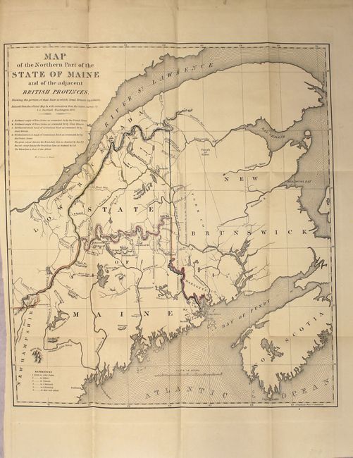
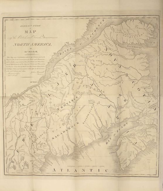
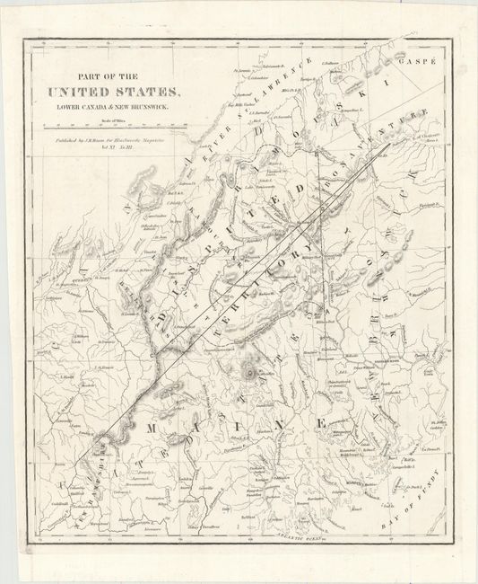
"[Lot of 3] Map of the Northern Part of the State of Maine and the Adjacent British Provinces... [and] Extract from a Map of the British and French Dominions in North America [and] Part of the United States, Lower Canada & New Brunswick",

Subject: Northeastern United States & Canada

Period: 1838-40 (circa)

Publication:

Color:

Size:
See Description
Download High Resolution Image
(or just click on image to launch the Zoom viewer)

A. [Lot of 2] Map of the Northern Part of the State of Maine and the Adjacent British Provinces..., hand color (15.1 x 16.7") and Extract from a Map of the British and French Dominions in North America, black & white (13.4 x 13.5"), by U.S. Government, from Sen. Doc. 502, 25th Congress, 2nd Session, published 1838. The first map details the boundary dispute between the United States and Great Britain relating to Maine. Hand coloring is used to show the boundary as claimed by the United States and by Great Britain, with a third line labeled "that of the Arbiter" which closely corresponds to Maine's present-day border with Canada. A table gives the major points of contention in this border dispute. Another table names land grants belonging to six land holders. The second map is in black and white and was included for historical purposes. It was extracted from Mitchell's map of 1755 by W.J. Stone. Both maps are still bound into the 16 pp. Senate report. Condition: Maps are very good with short binding tears that have been closed on verso with archival tape. The hand colored map also has a bit of faint offsetting. Text has occasional light foxing. (B+)

B. Part of the United States, Lower Canada & New Brunswick, by J.M. Mason, from Blackwoods Magazine, circa 1840, black & white (10.4 x 12.4"). This interesting map focuses on the Maine boundary dispute between the United States and Great Britain. The dispute was settled during the Aroostook War, a nonviolent confrontation that ended in 1842 with the Webster-Ashburton Treaty of Washington. The map depicts the topography of the land with the "Disputed Territory" well delineated. Adapted from an 1832 map by the Society for the Diffusion of Useful Knowledge, North America Sheet II Lower Canada and New Brunswick with Part of New York, Vermont and Maine. Published by J. M. Mason for Blackwoods Magazine. Condition: On a clean, bright sheet. Issued folding. (A)

References:

Condition:

See description above.

Estimate: $275 - $350

Sold for: $180

Closed on 5/4/2016

Archived