Catalog Archive
Auction 157, Lot 140

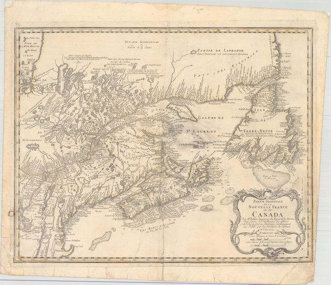
"Partie Orientale de la Nouvelle France ou du Canada", Bellin/Homann Heirs

Subject: Colonial Northeastern United States & Canada

Period: 1755 (dated)

Publication:

Color: Hand Color

Size:
21.1 x 16.9 inches
53.6 x 42.9 cm
Download High Resolution Image
(or just click on image to launch the Zoom viewer)

This is Bellin's definitive map of eastern Canada and New England showing the mouth of the St. Lawrence, the length of the river, the Maritime provinces and French claims in the region. There are some very interesting details of the coastal towns, showing Havre de Baston for Boston Harbor, up the coast to Portsmouth in New Hampshire, Wells, York and Cape Elizabeth in Maine. There is considerable information shown on the extent of French exploration in the region. Large decorative cartouche incorporates two distance scales. This example is from the second plate with the imprint "A Paris chez R.J. Julien a l'Hotel…" removed, the date changed and various geographical improvements. Blank verso. This large format Bellin map was published in several atlases by Homann.

References: Kershaw #690; McCorkle #745.1, Sellers and Van Ee #273.

Condition: B

Original outline color on watermarked paper with a few areas of printer's ink residue. There is a long centerfold separation at bottom, an adjacent 3" tear, and another 2" tear along the centerfold that have all been repaired on verso with hinge tape. Small chips in the lower corners of the map and minor edge tears have all been repaired on verso with a combination of archival and non-archival materials. See image of verso.

Estimate: $550 - $700

Unsold

Closed on 5/4/2016

Archived