Catalog Archive
Auction 156, Lot 812

"Monographs of the United States Geological Survey Volume IV. Comstock Mining and Miners", U.S. Geological Survey (USGS)

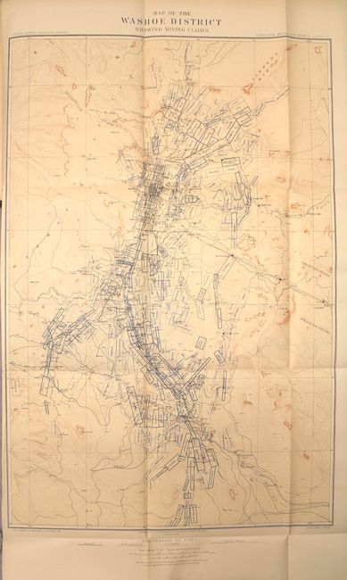
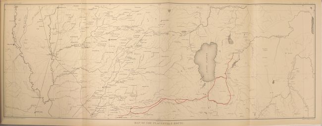
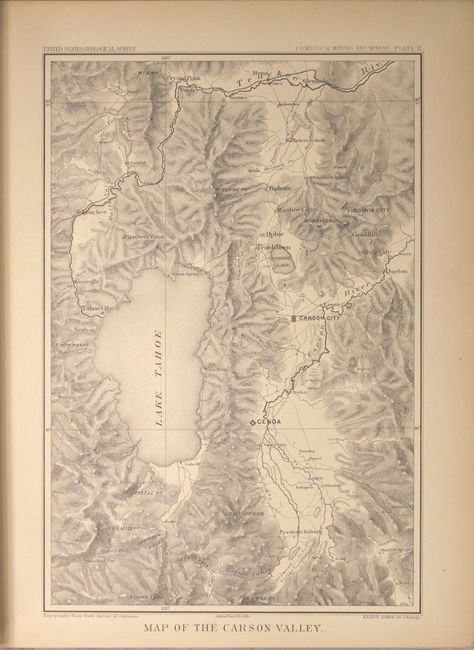
Subject: Exploration and Surveys

Period: 1883 (published)

Publication:

Color: Printed Color

Size:
9.5 x 12 inches
24.1 x 30.5 cm
Download High Resolution Image
(or just click on image to launch the Zoom viewer)

This report by Elliot Lord is a must for any Nevada, mining or Comstock Lode collection. It is complete with three maps: 1) "Map of Placerville Route" (29 x 10"). This folding map details the routes with red overprinting. It extends from Colusa and Marysville in the west to Carson City and Virginia City and beyond. 2) "Map of the Carson Valley" (10 x 8") has original tissue guard. It is a fully engraved map which shows all of Lake Tahoe and locates Carson City, Reno, Truckee, Dayton, Silver City, Gold Hill, etc. 3) The large, folding "Map of the Washoe District Showing Mining Claims" (27 x 18") is a remarkably detailed map showing the gold and silver operations in the vicinity of Virginia City. The map's geography and topography is a product of Capt. G.M. Wheeler's Expeditions of 1876-77 for the Surveys West of the 100th Meridian. It is difficult to overstate the number of claims shown; perhaps as many as 100 in a patchwork mosaic cover the region so completely it is difficult to see place names. Scores of mills including Sherman, French's, Humphreys, Nevada and many more are identified. The Sutro Tunnel is detailed with the tunnel entrance located.

The area first drew the interest of gold prospectors in the 1850's. They struggled with the heavy, gooey mud that clung to picks and shovels. When assayed this troublesome muck proved to contain silver ore worth over $2,000 a ton - in 1859 dollars - not counting the gold content! This rich lode caught the attention of President Lincoln who realized its mineral wealth could help keep the Union solvent during the Civil War. In 1864 he made Nevada a state, bypassing the sticky problem that it did not contain enough people to be constitutionally eligible for statehood. A remarkable map attesting to the manic mining activities of the day.

451 pp., hardbound in brown cloth with gilt title on spine.

References:

Condition: A

Maps and text are near fine with pleasant even-age toning. The one exception is the map of the Placerville Route which was detached along the left fold and skillfully reattached with archival tape (B) - see images. Covers and spine show typical shelf wear along with a few scratches and abrasions.

Estimate: $400 - $500

Sold for: $250

Closed on 2/17/2016

Archived