Catalog Archive
Auction 156, Lot 771

"[Lot of 3] Carte de la Cote N.O. de l'Amerique et de la Cote N.E. de l Asie... [and] Carte de l'Entree de Norton et du Detroit de Bhering... [and] Carte de la Riviere de Cook, dans la Partie N.O. de l'Amerique", Bonne, Rigobert

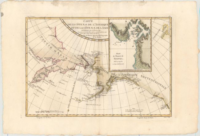
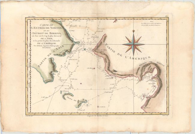
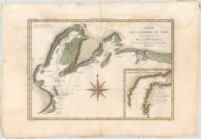
Subject: North Pacific Ocean

Period: 1785 (circa)

Publication: Atlas Encyclopedique

Color: Hand Color

Size:
13.6 x 9.3 inches
34.5 x 23.6 cm
Download High Resolution Image
(or just click on image to launch the Zoom viewer)

Captain James Cook (1728-1779) is best known for his three voyages to the Pacific (1768-71; 1772-75; and 1776-79). His discoveries radically changed the western understanding of the world in the late 18th century. He was the first to circumnavigate and chart New Zealand and provided the earliest European accounts of exploration along the eastern coast of Australia and the Hawaiian Islands. On February 14th, 1779, he was killed on Hawaii after attempting to kidnap the chief of the island.

Many contemporary accounts of Cook’s voyages, including charts and engravings, appeared in the late 18th century. The first official account of Cook’s first voyage was published in 1773 by John Hawkesworth in Volumes II and III of An Account of the Voyages Undertaken by the Order of His Present Majesty for Making Discoveries in the Southern Hemisphere... William Strahan and Thomas Cadell published the first official accounts of the second and third voyages in 1777 and 1784. Accounts of his exploration were subsequently translated into French, German, and Dutch.

A. Carte de la Cote N.O. de l'Amerique et de la Cote N.E. de l Asie... Fascinating map showing the explorations of Capt. Cook's expedition in Alaska, the Bering Strait and Kamchatka. The track of his ship in 1778 and 1779 are shown, as well as soundings. Condition: A strong impression with very light soiling and two small wormholes adjacent to the centerfold. (B+)

B. Carte de l'Entree de Norton et du Detroit de Bhering... Based on the expeditions of Captain Cook, this great map covers the Bering Strait from south of Norton Sound to north of Cap du Prince de Galles and the corresponding coastline of Russia. It shows the Chukotskiy and Seward peninsulas and parts of St. Lawrence Island (here Isles de Clerke). Features include islands, place names, soundings, and hachures representing coastal mountains. The tracks of both the 1778 and 1779 explorations are delineated; Cook having done the former and Clerke the latter after Cook's death in Hawaii in February 1779. Decorated with a large compass rose. Reference: Falk #1788-2. Condition: Nice impression on watermarked paper with two small wormholes adjacent to the centerfold and a light damp stain that enters the image at top. (B)

C. Carte de la Riviere de Cook, dans la Partie N.O. de l'Amerique. This handsome map shows Capt. Cook's discoveries in Prince William Sound and Cook Inlet and includes the track and anchor points of the Resolution. The map is inset with Plan du Havre de Samganoodha, dans l'Isle de Oonalaska. A large compass rose dominates the center. Condition: Nice impression on watermarked paper with two small wormholes adjacent to the centerfold and a light damp stain that enters the image at top. (B)

References:

Condition:

See description above.

Estimate: $200 - $240

Sold for: $100

Closed on 2/17/2016

Archived