Catalog Archive
Auction 156, Lot 415

Scarce Sea Chart with References to African Slave Trade

"The Atlantic Ocean by Governor Pownall F.R.S.", Jefferys/Sayer & Bennett

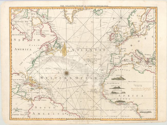
Subject: North Atlantic

Period: 1787 (dated)

Publication: The West-India Atlas...

Color: Hand Color

Size:
25.1 x 19.7 inches
63.8 x 50 cm
Download High Resolution Image
(or just click on image to launch the Zoom viewer)

Thomas Jefferys was one of the most important English map publishers of the 18th century. His work included prints and maps of locations around the world, but his most notable maps are of North America and the West Indies. He began his career in the map trade in the early 1730s, working as an engraver for a variety of London publishers, and eventually setting up his own shop. In 1746, he was appointed Geographer to the Prince of Wales, and in 1760 he became Geographer to the King. These titles granted access to manuscripts and cartographic information held by the government. In the early 1760s he embarked on an ambitious project to produce a series of English county maps based on new surveys, but ran out of money and filed for bankruptcy in 1766. He then partnered with London publisher Robert Sayer, who reissued many of Jefferys plates and continued to issue new editions after Jefferys' death in 1771. Jefferys' American Atlas and the accompanying West-India Atlas, published post posthumously, are considered his most important cartographic works.

Striking and very scarce sea chart focuses on the Atlantic Ocean and shows coastal detail of Hudson Bay, Greenland, Iceland, Europe, West Africa, the Spanish Main, the Caribbean and the east coast of North America. The sea is meticulously mapped with arrows charting currents, directional lines for winds, and an unusual shaded area to indicate the Gulf Stream, or Florida Stream. This map is one of the earliest to correctly indicate the Gulf Stream, after Benjamin Franklin's famous map of 1786. Franklin was well acquainted with Englishman Thomas Pownall, who created this chart for his Hydraulic and Nautical Observations on the Currents in the Atlantic Ocean, published in 1787.

One of the most interesting features of this chart are the references to the slave trade from the manuscript notations that are contemporary with the creation of the map. There is a note in Africa that states in an abbreviated form: Whydah Road, lies in Lat. 6°, 27' N, and from Norris's Mem. Long: 3° 42' E:. This refers to a book published by a slave trader titled, Memoirs of the Reign of Bossa Adahee, King of Dahomy… A Short Account of the African Slave Trade by Robert Norris, published in 1789. Bossa Ahadee ruled from 1732-74 and was known for his attempts to depopulate Africa by supplying up to 20% of the slaves to the Americas and to Europe through Wydah (shown as Widah on the map). There is also a manuscript route, laid down with aid of a compass that shows the route from Liverpool, where Norris left, to Africa and then the Middle Passage picks up from an established course to the Caribbean, where the slaves would be sold. A previous owner of this map used it to track a slave-trading voyage to Whydah (now called Ouidah in present-day Benin), located at that time in Guinea on the Gold Coast.

References: The Map Collector 15, pg 8.

Condition: B+

There is an edge tear at bottom that extends 1.3" into the map image that has been closed on verso with archival material. The unusual shaded area in the Atlantic is as issued, with some manuscript contemporary to the map - see description.

Estimate: $1,400 - $1,700

Sold for: $1,000

Closed on 2/17/2016

Archived