Catalog Archive
Auction 156, Lot 316

"Richmond Henrico County Manchester and Springhill Chesterfield Co. (Virginia.)",

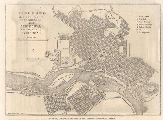
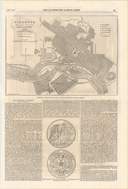
Subject: Richmond, Virginia, Civil War

Period: 1861 (dated)

Publication: Illustrated London News

Color: Black & White

Size:
9.4 x 6.8 inches
23.9 x 17.3 cm
Download High Resolution Image
(or just click on image to launch the Zoom viewer)

This bird's-eye plan of Richmond was published just a few months after the city was chosen as the new capital of the Confederacy on May 21, 1861. The English were eager to learn about this Civil War in their former colonies, and this is one of the earliest maps depicting Richmond published in a newspaper. The map extends south across the James River to also show Manchester and Springhill (now Southside) in Chesterfield County. The Hollywood Cemetery is shown, as is Broad Rock Island, now known as Belle Isle. A numbered key identifies the State House, City Hall, State Armory, Medical College, and three railroad depots. Drawn and engraved by T. Ettling. Full sheet with text measures 10.6 x 15.8". On verso are images of the interior and exterior of Her Majesty's Carriage on the London and North-Western Railway. Published September 7, 1861.

References:

Condition: A

Clean and bright on watermarked paper with remnants of hinge tape at sides.

Estimate: $300 - $400

Sold for: $220

Closed on 2/17/2016

Archived