Catalog Archive
Auction 156, Lot 226

"Map Showing the Route Pursued by the Exploring Expedition to New Mexico and the Southern Rocky Mountains… [with report]", Fremont, John Charles

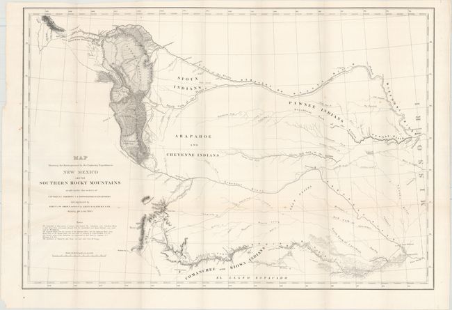
Subject: Western United States

Period: 1845 (published)

Publication: Expedition to the Upper Arkansas River

Color: Black & White

Size:
27.8 x 19.4 inches
70.6 x 49.3 cm
Download High Resolution Image
(or just click on image to launch the Zoom viewer)

This famous map by Lt. Abert, assisted by Lt. Peck is considered of great importance as it shows the first precise astronomical observations in this unknown part of the country. It covers the area from Missouri to the Rocky Mountains, as far north as Ft. Laramie and south to Santa Fe. The entire length of the Santa Fe Trail is detailed, including the location of Council Groves and Pawnee Rock. The map is accompanied by the 75-page Senate Doc No.438, 29th Congress, 1st Session with includes 11 additional illustrative plates along the route including "Wah-to-yah, or The Spanish Peaks" and "View of the Santa Fe Road." 8vo, rebound in brown faux-leather with tips over black cloth-covered boards with raised bands on spine and marbled endpapers.

References: Wheat (TMW) #489; Wagner Camp #120.

Condition: B+

Condition code is for the map, which is clean and bright with a few spots of foxing and a few extraneous creases at left where the map folded into the report. Text is toned with scattered foxing to both plates and text. Modern binding is pristine.

Estimate: $500 - $600

Sold for: $600

Closed on 2/17/2016

Archived