Catalog Archive
Auction 155, Lot 759

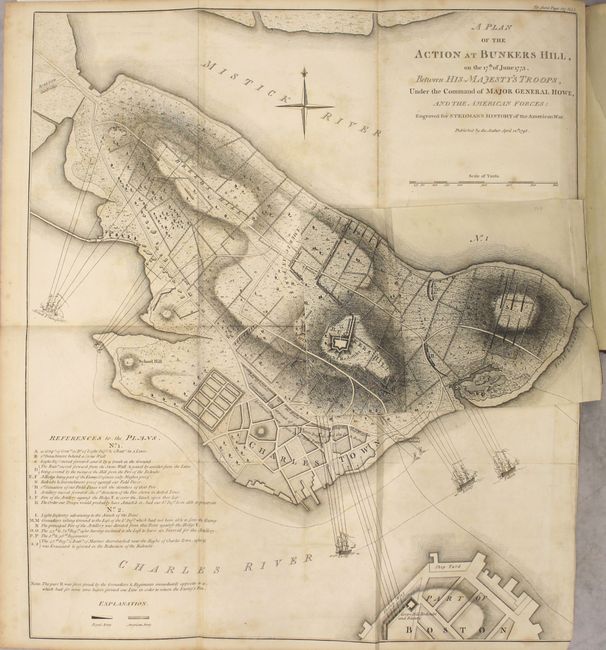
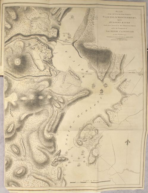
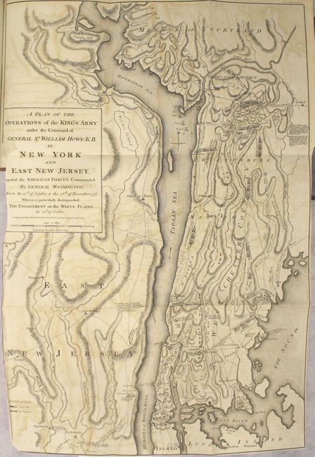
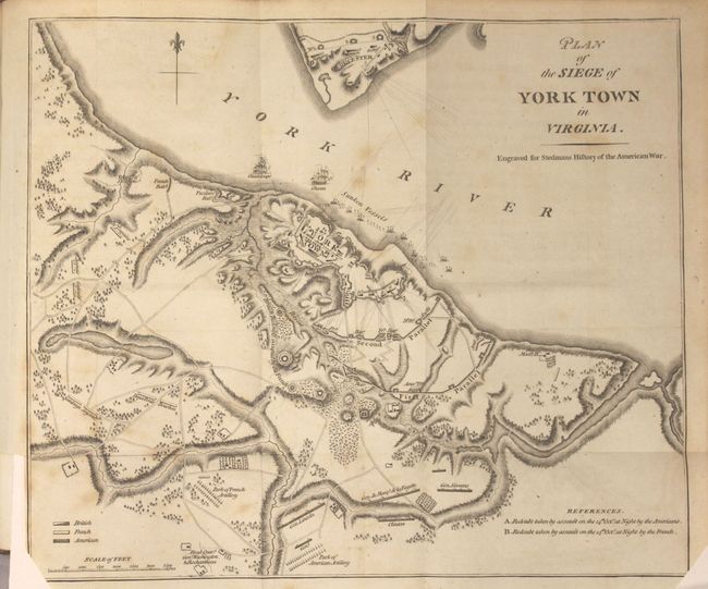
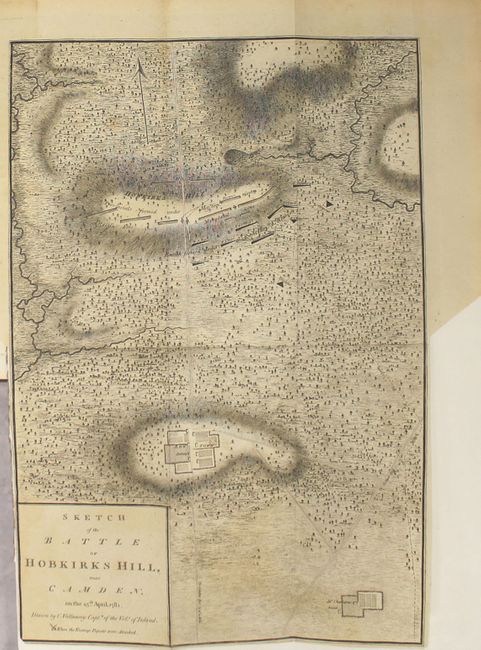
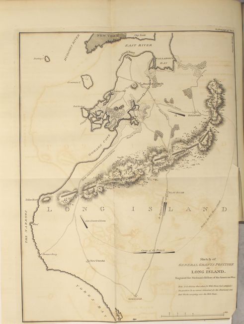
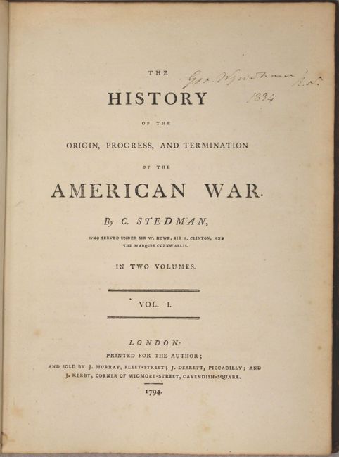
Complete First Edition of Stedman's History of the American Revolution

"[2 Volumes] The History of the Origin, Progress, and Termination of the American War", Stedman, Charles

Subject: History Books, American Revolution

Period: 1794 (published)

Publication:

Color: Black & White

Size:
8.6 x 11 inches
21.8 x 27.9 cm
Download High Resolution Image
(or just click on image to launch the Zoom viewer)

Charles Stedman was an American-born officer who served in the British Army during the American Revolution. Stedman served under Howe, Clinton and Cornwallis, and wrote a history on the war with explanations of the military campaigns and depictions of battle plans. According to Sabin, Stedman's account is "generally considered the best contemporary account of the Revolution written from the British side." The work includes 15 engraved maps, 11 of which are folding:

A. A Plan of the Action at Bunkers Hill (16.7 x 18.9"). This is the second state of the famous 1775 map by Lieutenant Thomas Hyde Page with the ground plan by Captain John Montresor. It illustrates the first major conflict of the two armies and is precisely detailed. The map was originally published by William Faden shortly after the battle and then appeared again in Stedman's History . Stedman's map is faithful to the original including the pasted down overlay map (9" x 6") titled "No. 1," which is often found missing. Stedman's plan is nearly identical to Faden's, with the key exception of the title. Faden refers to the opposition as the Rebel Forces, whereas Stedman refers to them as the American Forces. In addition, Stedman omits the attribution to Lieut. Page and Capt. Montresor. Stedman also clarifies the location of the British and American troops by identifying the rectangular formations with different shading. Ref: Nebenzahl (Biblio) #29; cf. Nebenzahl & Higginbotham (Amer. Rev.) #4. Condition: Light foxing and offsetting, with an unrepaired fold separation that enters 1" into map at right and an adjacent 2" tear that has been professionally repaired. The bottom right corner has been trimmed just inside the neatline. The overlay is in very good condition with a few minor spots of foxing. (B)

B. Plan of the Attack of the Forts Clinton & Montgomery, upon Hudsons River… (20.2 x 26"). This attractive plan is identical to the one by Lt. John Hills (published by William Faden in 1784). It is an incredibly detailed plan (on a scale of about 600 yards to the inch) of the Hudson River in the area of Forts Montgomery, Clinton, Independence, Peekskill, Kings Ferry, etc. The British fleet is shown in the river with the dates of various landings. Ref: Stevens & Tree (MCC-39) #21b. Condition: Light offsetting. (B+)

C. A Plan of Operations of the King's Army [...] in New York and East New Jersey against the American Forces Commanded by General Washington From the 12th of October, to the 28th of November 1776 (19.3 x 28.2"). Condition: Moderate offsetting. Trimmed inside the neatline along the title cartouche, with the bottom left corner trimmed just inside the neatline. (B)

D. Plan of the Siege of York Town in Virginia (12.8 x 10.8"). Condition: Light foxing. The bottom corners have been trimmed just inside the neatline. (B+)

E. Plan of the Siege of Savannah, with the Joint Attack of the French and Americans on the 9th Obtober 1779... (22.5 x 16"). Condition: Moderate offsetting with two small areas of toning at top. (B)

F. A Topographical Map of the North Part of New York Island (10 x 18.1"). Condition: Moderate offsetting. The bottom corners have been trimmed just inside the neatline. (B)

G. Plan of the Siege of Charlestown in South Carolina (11.6 x 10"). Condition: Light offsetting. The left-hand corners have been trimmed just inside of the neatline. (B+)

H. Position of the English and French Fleets Immediately previous to the Action on the 5th Sept. 1781 (10 x 8.3"). Condition: Light offsetting and toning. The right-hand corners have been trimmed, with the bottom corner being trimmed just inside the neatline. (B+)

I. Sketch of the Battle of Hobkirks Hill near Camden on the 25th April 1781 (11.6 x 16.9"). Condition: Light offsetting with minor toning. (B+)

J. Sketch of General Grants Position on Long Island (10.6 x 13.9"). Condition: Moderate offsetting with a 1/2" binding tear. The bottom right corner has been trimmed just inside the neatline. (B)

K. Plan of the Position which the Army under Lt. Genl. Burgoine Took at Saratoga on the 10th of September 1777 (18.7 x 8.5"). Condition: Light toning with moderate offsetting (B)

L. Sketch of Fayette's Position at Barren Hill (6.7 x 8.5"). Condition: Minor offsetting from opposing page of text. (A)

M. Plan of the Battle Fought near Camden August 16th 1780 (7.5 x 8.3"). Condition: Light toning. (B+)

N. Sketch of the Catawba River (6.9 x 6.7"). Condition: Light toning with minor offsetting from the opposing page of text. (B+)

O. Battle of Guildford, Fought on the 15th of March 1781 (7.5 x 8.2"). Condition: Light toning. (B+)

2 Volumes, quarto. Vol. I, 399 pp., 7 maps; Vol. II, 449 pp., 8 maps. Hardbound in full leather, flat spines divided into six compartments with gilt tooling, black morocco labels with title and volume numbers in gilt.

References: Howes #S914; Sabin #91057; Shirley (BL Atlases) G.STED-1a.

Condition:

See above for condition of each map. Text is clean and bright with occasional minor foxing. The hinges are starting and the covers show light wear with a few small abrasions. Previous owner's bookplate is on front pastedown of both volumes.

Estimate: $6,000 - $7,500

Sold for: $4,500

Closed on 11/18/2015

Archived