Catalog Archive
Auction 155, Lot 103

"Carte Reduite des Cotes de l'Acadie, de l'Isle Royale, et de la Partie Meridionale de l'Isle de Terre-Neuve...", Chabert de Cogolin, Joseph Bernard Marquis de

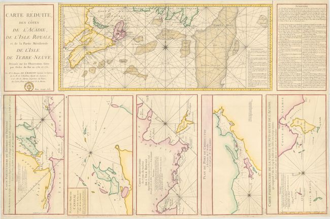
Subject: Eastern Canada

Period: 1784 (published)

Publication: Neptune Americo-Septentrionale

Color: Hand Color

Size:
34 x 22.4 inches
86.4 x 56.9 cm
Download High Resolution Image
(or just click on image to launch the Zoom viewer)

Fine large-scale sea chart from this important French voyage of discovery. The main map covers the Canadian Maritimes and the important fishing banks. At bottom are five large inset charts providing details in the region:

1) Carte Particuliere du Detroit de Fronsac is a chart of the mouth of the Fronsac River and Isle Madame.
2) Plan du Port de Canseau features Canso (Grassy Island) and locates the ruins of a fort.
3) Carte Particuliere des Costes du Sud Est de l' Isle Royale depuis l' Isle covers part of the coast of present-day Cape Breton Island with Isle de Scatari and the fortifications of Louisbourg.
4) Plan du Port de Chibouctou a la Coste de l'Acadie shows the entrance to Halifax.
5) Carte Particuliere de la Pointe du Sud-Ouest de l' Acadie qui comprend l' Isle du Cap de Sable et les Isles aux Loups marins covers the southwestern coast and Cape Sable.

All are decorated with a compass rose indicating the magnetic variation. Engraved by Dheulland.

References: Kershaw #702.

Condition: B+

On watermarked paper with a few short tears that have been archivally repaired and light printer's ink residue.

Estimate: $400 - $500

Unsold

Closed on 11/18/2015

Archived