Catalog Archive
Auction 154, Lot 98

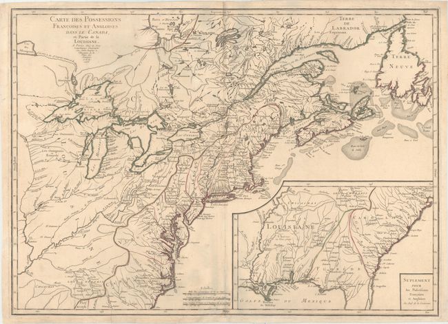
First State of Longchamp's Map of the Theater of the French and Indian War

"Carte des Possessions Francoises et Angloises dans le Canada, et Partie de la Louisiane", Longchamp, S. G. (Sieur)

Subject: Colonial Eastern United States & Canada

Period: 1756 (dated)

Publication:

Color: Hand Color

Size:
30 x 21.6 inches
76.2 x 54.9 cm
Download High Resolution Image
(or just click on image to launch the Zoom viewer)

This is the first state of this separately published map of the colonial United States and Canada. It was issued to provide information about the theater of the French and Indian War, which was formally declared in 1756 and continued until 1763. The map shows the region from Labrador and Hudson Bay across to Assiniboine Lake and south to the Carolinas, including the Mississippi and Ohio River valleys. The Great Lakes are mapped with the inclusion of the imaginary islands of Phelipeaux, Maurepas, and St. Anne in Lake Superior. The Southeast, excluding the southern tip of Florida, is shown in a large inset map. French Louisiane is between the Mississippi River and the Spanish territory of Florida, which extends north to the Monts Apalaches in a triangular shape. An amorphous Georgia is squeezed between Florida and Carolina. There are numerous Indian villages and early forts located.

References: Kershaw #358; McCorkle #756.9; Sellers & Van Ee #70.

Condition: B+

Original color on watermarked paper with very light soiling. There are archival repairs to several short separations along the centerfold and a few tiny holes in the image. There are some bluish shadows along the centerfold that are caused by our scanner and do not appear on the map.

Estimate: $1,600 - $1,900

Sold for: $1,400

Closed on 9/16/2015

Archived