Catalog Archive
Auction 154, Lot 725

Rare Spanish Map Showing Sea of the West

"Mapa de la America Septentl. Asia Oriental y Mar del Sur Intermedio Formado Sobre las Memorias Mas Recientes y Exactas Hasta el Ano de 1754", Venegas, Miguel (Padre)

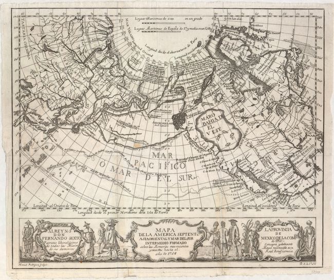
Subject: North Pacific Ocean

Period: 1756 (dated)

Publication: Noticia de la California

Color: Black & White

Size:
14.1 x 11.8 inches
35.8 x 30 cm
Download High Resolution Image
(or just click on image to launch the Zoom viewer)

This very rare Spanish map depicts a large Sea of the West based on the Delisle.Buache model, named Maro Bahia de el Vest. It depicts the discoveries of the Russians in the early 18th century, including the tracks of Bering's first and second voyages, Joseph Nicolas Delisle's voyage with Capt. Tchirikow in 1741, the track of De Frondat's voyage from China to California in 1709. The route of the Spanish Galleons from Acapulco, Mexico to Manilla, Philippines in 1743 are also shown. These ships regularly carried immense quantities of gold and treasure along the route, until they were captured by Commodore George Anson in June 1743.

The west coast of North America is entirely fictitious north of C. Blanco de S. Sebas with an enormous Sea of the West and Lago de Velas. A network of rivers and lakes making up most of a Northwest Passage is derived from the apocryphal voyages of the Spanish Admiral Bartholome de Fonte. Below the map are three elegant in rococo cartouches surrounded by Chinese, European and Native American figures.

This map was published in Miguel Venegas' Noticia de la California in 1764, which is considered one of the first histories of California. Engraved by Manuel Rodriguez, the map was included in Venegas' work without the authorization of his editor, Father Andres Marcos Burriel. Burriel did not agree with the concepts of a Sea of the West or Northwest Passage, and did not include this map in later editions of the work, hence the rarity of this map.

References: Kershaw #1217; McGuirk #64; Wagner #585; Wheat (TMW) #138.

Condition: B

A dark, crisp impression issued folding on watermarked paper with a small stain near the center of the map. There are several long fold separations at bottom and a 2" binding tear at left that had been closed on verso with non-archival tape, which has since been professionally removed and the separations properly closed with archival material.

Estimate: $1,500 - $1,800

Sold for: $1,000

Closed on 9/16/2015

Archived