Catalog Archive
Auction 154, Lot 417

"The Roads from London, to Wells in Norfolk and St. Edmons Bury in Suffolk...", Ogilby, John

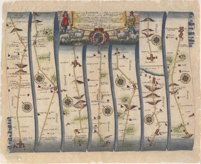
Subject: Eastern England

Period: 1675 (circa)

Publication: Britannia

Color: Hand Color

Size:
17.4 x 12.9 inches
44.2 x 32.8 cm
Download High Resolution Image
(or just click on image to launch the Zoom viewer)

John Ogilby's 'Britannia' was published between 1675 and 1698. It is a landmark in the mapping of England and Wales. Its unique format constituted the first national road-atlas of any country in Western Europe. It was composed of maps of seventy-three major roads and cross-roads, presented in a continuous strip-form, on a uniform scale of one inch to a mile. Each beautiful map includes wonderful detail of the countryside with each strip containing a large compass rose to indicate changes in direction.

This attractive strip-style map covers 74 miles of roads in Norfolk and Suffolk. It is in the pictorial style pioneered by Ogilby with the road laid out in several ribbon-like panels. Each of the seven panels has a decorative compass rose to orient the traveler. The route travels 60 miles from Wells-next-the-Sea in Norfolk south to Newmarket in Suffolk, and then continues 14 miles east to Bury St. Edmunds. Embellished with a strapwork title cartouche featuring a male and female shepherd with their herd.

References: Moorland & Bannister, pp. 157-8; Shirley (BL Atlases) T.OGIL-4a #52.

Condition: B+

A nice impression with attractive color, very light soiling, and a few minor creases. There are archival repairs to short centerfold separations at top and bottom, and the edges of the sheet have been backed in archival tissue to repair numerous small chips and tears confined to the blank margins.

Estimate: $240 - $300

Sold for: $180

Closed on 9/16/2015

Archived