Catalog Archive
Auction 154, Lot 20

Rare Decorative World Map with Geographical Misconceptions

"Haemisphaeriorum Tabula Carthesiana", Schenk, Pieter
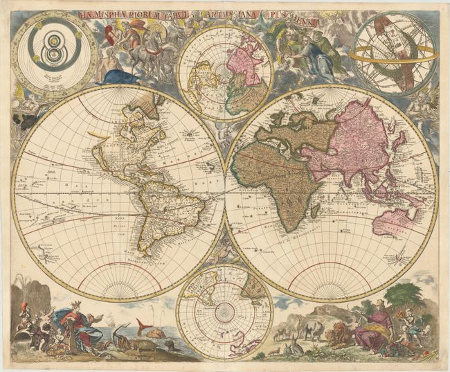
Subject: World

Period: 1700 (circa)

Publication:

Color: Hand Color

Size:
23.4 x 19.3 inches
59.4 x 49 cm
Download High Resolution Image
(or just click on image to launch the Zoom viewer)

This very rare map is a stunning example of the baroque style that was popular at the end of the 17th century. Surrounding the map are delightful allegorical scenes with mythological figures in the clouds at top, including Atlas, Diana of Ephesus, and a figure at left who is half man and half bird. At bottom are scenes depicting the animals of the earth, with a goddess of the sea attending the aquatic animals, and Cybele, goddess of Mother Earth, presiding over the terrestrial animals. In the top corners of the sheet are diagrams of the solar system and of the earth surrounded by signs of the zodiac and astronomical planes.

The double-hemisphere world map includes polar projections and depicts common geographical misconceptions. California is depicted as an island and to the north a long coastline extends west towards Asia, separated from North America by the Straet Anian. Greenland is connected to North America, and the United States and Canada are divided into Nova Mexico, Louisiane, and Canada hodie Nova Francia. The mouth of the Mississippi River is depicted too far west, extending nearly to the Rio Grande. Australia, Van Diemen's Land, and New Zealand are only partially delineated, and Australia appears almost connected to N. Guinea.

Shirley indicates that this map was occasionally bound in Schenk's Atlas Contractus, and may also have been published separately. Engraved by Abraham Deur.

References: Shirley #637.

Condition: A

Original color in the map with later color in the decorative elements. Professionally remargined at right and left to accommodate framing. A lovely example.

Estimate: $5,000 - $6,500

Sold for: $4,000

Closed on 9/16/2015

Archived