Catalog Archive
Auction 154, Lot 18

Rare World Map on a Singular Polar Projection

"Nieuw Aerdsch Pleyn", Robijn (Robyn), Jacobus
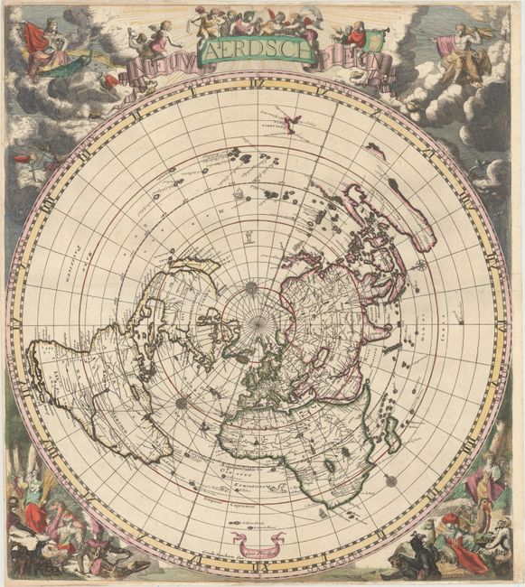
Subject: World

Period: 1700 (circa)

Publication:

Color: Hand Color

Size:
20.9 x 23.7 inches
53.1 x 60.2 cm
Download High Resolution Image
(or just click on image to launch the Zoom viewer)

This magnificent world map on a single polar projection was inspired by Cassini's map of 1650. Based on Jacob Robyn and Hendrick Doncker's four-sheet world map, this edition was also likely devised by Andreas van Luchtenburg, with the surrounding allegorical scenes engraved by Jacob Harrewyn. This is the second state with Robyn's imprint replaced with that of Cornelis Danckerts. The map is presented in a circular form on the equidistant azimuthal projection created by Le Mayerne Turquet in 1648, in which the latitudes appear as equidistant concentric circles. In North America, only one Great Lake is depicted, and Nieu Nederland appears on the East Coast as opposed to New York, as it was renamed in 1644. California is shown as an island with a flat northern coastline. In South America, the two mythical lakes Parime Lacus and Xarayes are depicted. Parts of New Zealand and Tasmania are also shown, and Australia is connected to New Guinea.

References: Shirley #582.

Condition: B+

A clean and bright example with full original color. Issued folding, now pressed, with minor professional repairs at the fold intersection and a couple of printer's creases. Professionally remargined at top and bottom with a sliver of image skillfully and seamlessly replaced in facsimile.

Estimate: $6,000 - $7,500

Sold for: $4,000

Closed on 9/16/2015

Archived