Catalog Archive
Auction 154, Lot 163

"A Map of the New Governments, of East & West Florida", Gibson, John

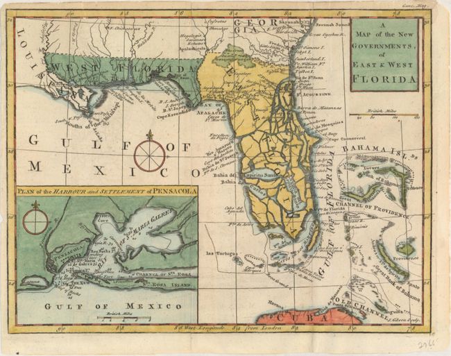
Subject: Colonial Southern United States, Florida

Period: 1763 (published)

Publication: Gentleman's Magazine

Color: Hand Color

Size:
9.9 x 7.6 inches
25.1 x 19.3 cm
Download High Resolution Image
(or just click on image to launch the Zoom viewer)

This map was published in November 1763 just a few weeks after the British acquisition of Florida at the conclusion of the French and Indian War. The region was divided into two British provinces, East and West Florida. The division was along the Apalachicola River, the boundary line for the Royal Proclamation of 1763 that extended from the Ohio River to Florida along the watershed of the Appalachian and Allegheny Mountains. The Proclamation was designed to reduce confrontation between Indians and colonists by outlawing English settlement west of the line. East Florida encompassed primarily the Florida peninsula; West Florida included the Gulf Coast region from the Apalachicola River to the Mississippi River south of 31° of latitude. The map locates many settlements, swamps, and rivers. Southern Florida is split by many waterways, giving the appearance that it's made up of numerous small islands. A large inset, Plan of the Harbour and Settlement of Pensacola, provides good detail of the Bay of Sta. Maria Galres (now Pensacola Bay) complete with soundings and a compass rose.

References: Cumming (SE) #336; Jolly #GENT-171.

Condition: B+

Issued folding with faint offsetting, several centerfold separations that are repaired on verso with archival material, and a couple of tiny marginal tears. Remnants of hinge tape on verso.

Estimate: $350 - $450

Sold for: $190

Closed on 9/16/2015

Archived