Catalog Archive
Auction 151, Lot 241

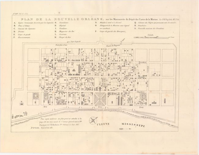
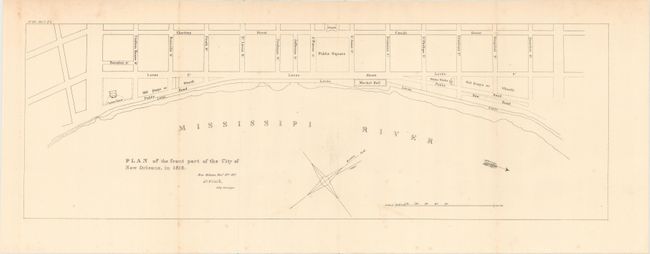
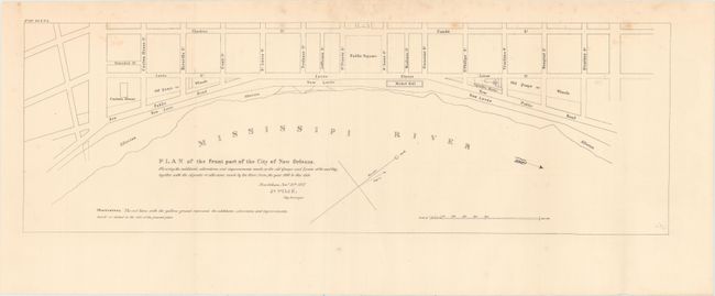
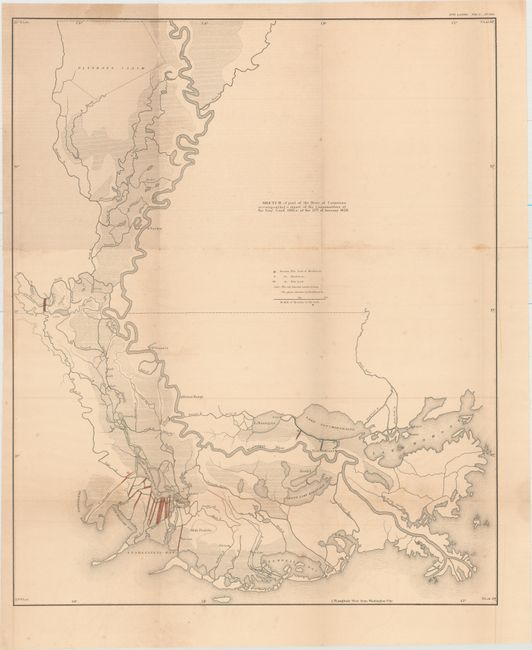
"[Lot of 4] Plan of the Front Part of the City of New Orleans... [and] Plan of the Front Part of the City of New Orleans, in 1818 [and] Plan de la Nouvelle Orleans... [and] Sketch of Part of the State of Louisiana...", U.S. Government

Subject: Louisiana

Period: 1860 (circa)

Publication: American State Papers

Color:

Size:
See Description
Download High Resolution Image
(or just click on image to launch the Zoom viewer)

The first three maps are based upon the original plans by Joseph Pilie, surveyor for New Orleans, which were included in Memorial of the Mayor, Aldermen, and inhabitants of New Orleans (HR Doc. 26, 20th Congress, 1st Session). The first plan shows the entire city laid out in a grid pattern with 18 important buildings identified by a key. The second and third show the first few streets that border the Mississippi River including the custom house, water works and Market Hall. The third map also shows the improvements made to the quays and levees. The last map, which is not listed in Claussen & Friis, depicts the course of the Mississippi River from north of Nachez, Mississippi to the Gulf of Mexico. It shows the drainage network of trenches and embankments along Lake Chetimaches (Grand Lake) and Lake Ponchartraine.

A. Plan de la Nouvelle Orleans, sur les Manuscrits du Depot des Cartes de la Marine, by Joseph Pilie, black & white (10.8 x 7.6").

B. Plan of the Front Part of the City of New Orleans, in 1818, by Joseph Pilie, black & white (21.9 x 7.3").

C. Plan of the Front Part of the City of New Orleans. Shewing the Additions, Alterations and Improvements Made on the Old Quays and Levees of the Said City..., by Joseph Pilie, black & white (21.9 x 7.1").

D. Sketch of Part of the State of Louisiana Accompanying a Report of the Commissioner of the Genl. Land Office of the 12th of January 1829, hand color (18.6 x 22.5").

References: cf. Claussen & Friis #10, #11 & #12.

Condition: B+

The first three maps are in very good condition with some minor scattered foxing. The fourth map is in good condition with light to moderate toning, very faint offsetting, and a few damp stains.

Estimate: $170 - $200

Sold for: $100

Closed on 11/19/2014

Archived