Catalog Archive
Auction 150, Lot 667

"Africae Dei Mater Alicubi Nota & Haec Ibidem Benefica", Scherer, Heinrich
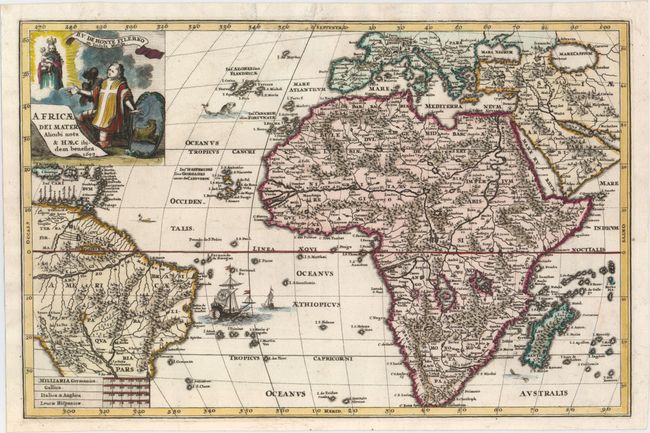
Subject: Africa

Period: 1699 (dated)

Publication: Atlas Novus

Color: Hand Color

Size:
14 x 9.1 inches
35.6 x 23.1 cm
Download High Resolution Image
(or just click on image to launch the Zoom viewer)

While this map is primarily focused on Africa, it also covers most of Europe, the Arabian Peninsula, the South Atlantic and most of Brazil and the Caribbean Islands. The Christian theme of this map of Africa is boldly presented in the graphic illustration of a Jesuit and a native African kneeling before the Virgin Mary and Jesus. The map itself is a fine example of the state of geographic knowledge (or lack thereof) at the beginning of the 18th century. The continent is presented with a fairly accurate coastline, but most of the interior is entirely fictional. The Nile is shown in the traditional manner with its source in the large southern lakes of Zaflan and Zembre. The Zembre, also labeled Lac Zaire spawns the Congo and Zaire Rivers as well. The locations of Catholic churches and missions are prominently shown. A missionary ship is shown off the coast of Brazil.

References: Shirley (BL Atlases) T.SHER-1a #38.

Condition: A

A clean, bright example with a sharp impression, attractive color, and one tiny pinhole in the southern Atlantic. A few creases have been pressed flat, and several of them have been reinforced on verso.

Estimate: $500 - $650

Sold for: $250

Closed on 9/17/2014

Archived