Catalog Archive
Auction 150, Lot 648

Rare Edition of Ptolemy's Map of Sri Lanka

"Duodecima Asie Tabula", Ptolemy/Germanus
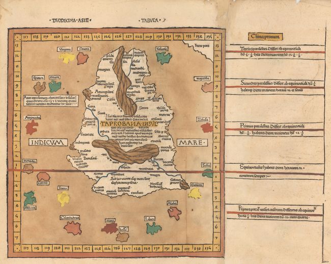
Subject: Sri Lanka

Period: 1486 (published)

Publication: Cosmographia

Color: Hand Color

Size:
15.3 x 11.6 inches
38.9 x 29.5 cm
Download High Resolution Image
(or just click on image to launch the Zoom viewer)

Claudius Ptolemy was a mathematician, astronomer and geographer who worked in Alexandria, then a part of the Roman Empire, in the 2nd century AD. One of the most learned and influential men of his time, his theories dominated both astronomy and geography for nearly 1500 years. His writings were kept alive by Arabic scholars during the Middle Ages and reemerged in Europe during the Renaissance. The birth of printing led to wide dissemination of his great works on astronomy and geography. There were a number of editions of his Geographia beginning in 1477. These early editions contained maps based on his original writings, known as Ptolemaic maps. As geographic knowledge increased with the explorations of Columbus, Magellan, Cabot and others, maps of the New World were added, and maps of the Old World were revised. Ptolemy's Geographia continued to be revised and published by some of the most important cartographers including Martin Waldseemuller, Sebastian Munster, Giacomo Gastaldi, Jodocus Hondius, and Gerard Mercator (whose last edition was published in 1730).

This rare woodblock map of Taprobana, which was variously thought to be Ceylon (Sri Lanka) or Sumatra, was the final map in the second edition of Cosmographia published in Ulm in 1486. The island is depicted with the geographical misconceptions typical of Ptolemy: it is too large, surrounded by 19 imaginary islands, and erroneously located to the southwest of India. Taprobana was often depicted in an outsized manner due in part to its importance to trade between Europe and Southeast Asia and also because of Marco Polo's false claim that the island had a circumference of 2400 miles. There are two mountain ranges that appear on the island, one running vertically in the north with two rivers flowing out of it, and another, perhaps the Knuckles Range, near the center of the island with three rivers emerging from it. Cities and settlements are located as well. Donnus Nicolaus Germanus was a Benedictine monk, cartographer, and printer who served as the editor of the 1482 and 1486 editions of Cosmographia. In addition to editing Jacobus Angelus's Latin translation, he also corrected and improved the maps. Printed for Justus de Albano de Venetiis by Johann Reger from the same blocks as the first edition, with new headings over the maps and reset Latin text on verso. According to Nordenskiold, the 1486 edition of the atlas is significantly rarer than its predecessor.

References: Mickwitz & Miekkavaara #200-32.

Condition: B+

A fine impression with lovely old color and professional repairs to a short worm track on the border at left and a few very small areas of loss along the centerfold with a minor amount of the neatline in facsimile. There is also faint foxing and some small chips and worm tracks in the far blank margins.

Estimate: $6,000 - $7,500

Unsold

Closed on 9/17/2014

Archived