Catalog Archive
Auction 150, Lot 524

"Tab. V. Europae, in qua Raetia, Pannonia, Noricum, Liburnia, Dalmatia, cum Italiae Parte...", Ptolemy/Mercator

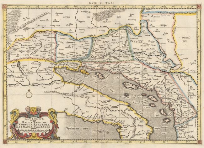
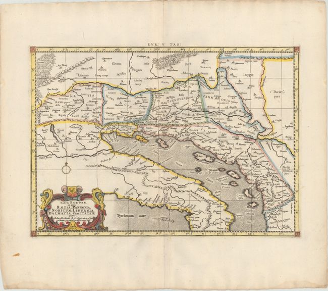
Subject: Southern Europe

Period: 1730 (circa)

Publication: Claudii Ptolemaei's Atlas Tabulae Geographicae Orbis Terrarum

Color: Hand Color

Size:
18.1 x 12.8 inches
46 x 32.5 cm
Download High Resolution Image
(or just click on image to launch the Zoom viewer)

Claudius Ptolemy was a mathematician, astronomer and geographer who worked in Alexandria, then a part of the Roman Empire, in the 2nd century AD. One of the most learned and influential men of his time, his theories dominated both astronomy and geography for nearly 1500 years. His writings were kept alive by Arabic scholars during the Middle Ages and reemerged in Europe during the Renaissance. The birth of printing led to wide dissemination of his great works on astronomy and geography. There were a number of editions of his Geographia beginning in 1477. These early editions contained maps based on his original writings, known as Ptolemaic maps. As geographic knowledge increased with the explorations of Columbus, Magellan, Cabot and others, maps of the New World were added, and maps of the Old World were revised. Ptolemy's Geographia continued to be revised and published by some of the most important cartographers including Martin Waldseemuller, Sebastian Munster, Giacomo Gastaldi, Jodocus Hondius, and Gerard Mercator (whose last edition was published in 1730).

An attractive Ptolemaic map of the Balkan coast and northern Italy along the Adriatic Sea, extending north to include parts of Austria and Hungary. The map is embellished with a strapwork cartouche and a sea monster. Mercator originally published this map in his 1578 edition of Ptolemy's great Geography. Although he is most renowned today for the projection he popularized and for first using the term Atlas for a collection of maps, he devoted much of his life to his Ptolemaic maps. The maps were beautifully engraved as nearly as possible to their original form and embellished with fine cartouches. This is the third state with a re-engraved title cartouche and the addition of a grid, published by R. and J. Westenios and Guil. Smith. There is evidence of a crack in the plate at bottom adjacent to the sea monster.

References: Mickwitz & Miekkavaara #235-23; Van der Krogt (Vol. I) #0905:1.3.

Condition: A

A nice impression with attractive color and wide margins. There is a damp stain on the bottom edge of the sheet, far from map image.

Estimate: $240 - $300

Sold for: $150

Closed on 9/17/2014

Archived