Catalog Archive
Auction 148, Lot 77

Important Map for Great Lakes Collectors

"Amerique Septentrionale par N. Sanson d'Abbeville…", Sanson/Mariette

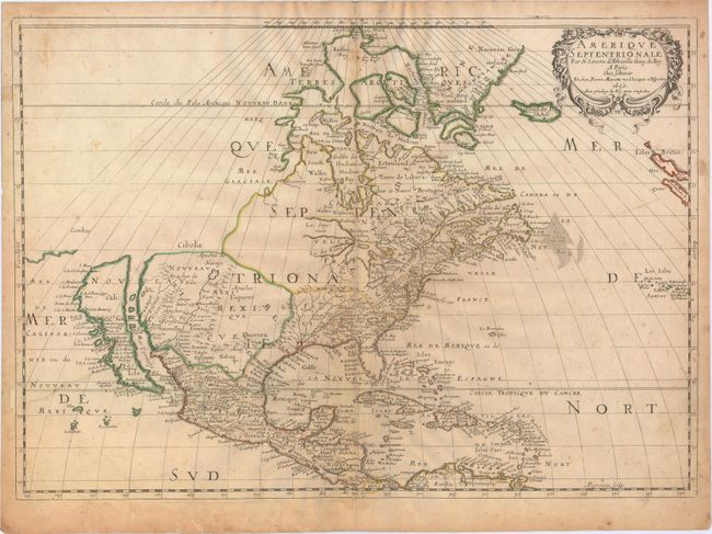
Subject: North America

Period: 1650 (dated)

Publication: Cartes Generales de Toutes les Parties du Monde…

Color: Hand Color

Size:
22 x 15.5 inches
55.9 x 39.4 cm
Download High Resolution Image
(or just click on image to launch the Zoom viewer)

Sanson's important map of North America is the first to show all of the Great Lakes in a recognizable form, and the first to name lakes Superior and Ontario. The Arctic bears the cartography typical of this date, with Greenland shown as three islands, and another three-island mass in Baffin Bay. Buttons Bay is left open-ended to the west, allowing the hopeful possibility of a Northwest Passage. The map extends to include Iceland and Britain, as well as Central America and the Caribbean. On the east coast, Nouvelle Amsterdam (New York) is located on a very small and misplaced island. Delaware is noted as N. Suede, the first such place name on a printed map referring to the Swedish colony located there in 1638. The Southeast features two fictional lakes near the Carolinas, and the Chesapeake Bay is greatly enlarged. Many native tribes are identified in New Mexico where the R. del Norte (Rio Grande) mistakenly flows from an interior lake and empties into the Mar Vermeio (Gulf of California). This is the third state of the map with Lake Ontario properly shaded. Engraved by A. Peyrounin.

References: Burden #294; McLaughlin #12; Wheat (TMW) #47; Pastoureau, Sanson V A [85].

Condition: B

Watermarked paper with an archivally repaired edge tear at lower left that extends 3.5" into the image, scattered foxing, and uneven toning. A long centerfold separation and two tiny worm holes along the centerfold have been professionally repaired. There are a few extraneous creases near the center of the image and one small manuscript note off the coast of Delaware.

Estimate: $2,500 - $3,250

Sold for: $1,900

Closed on 2/19/2014

Archived