Catalog Archive
Auction 148, Lot 713

The Earliest Map of the Continent Available to Collectors - First Edition

"Africa XVIII Nova Tabula", Munster, Sebastian
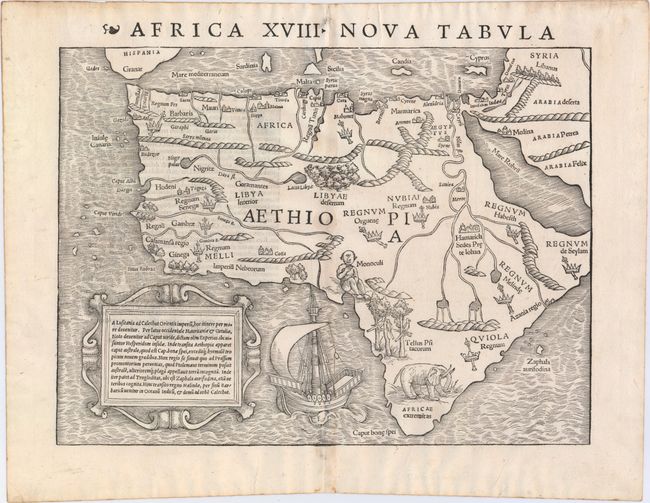
Subject: Africa

Period: 1540 (published)

Publication: Geographia Universalis…

Color: Black & White

Size:
13.6 x 10 inches
34.5 x 25.4 cm
Download High Resolution Image
(or just click on image to launch the Zoom viewer)

This is one of the first modern maps of the whole continent. The Ptolemaic geography, with large rivers and convoluted mountains, is augmented from Portuguese and Arabic sources. From the Portuguese comes Caput Bonespei (Cape of Good Hope) and a small group of islands off the eastern coast named Zaphala Aurifodina that were supposedly the region from which King Solomon imported gold and silver. The Arab kingdoms of Quiola and Melinde appear in eastern Africa and Hamarich, the capital of the mythical Christian king Prester John, is shown at the confluence of the twin sources of the Nile. The island of Madagascar is strangely absent, even though its presence was known from the time of Marco Polo. The map is illustrated with crowns and scepters, forests, parrots, an elephant, a Cyclops (Monoculi) and a large galleon under full sail. The strapwork cartouche contains a text description of the continent. This is from the first edition, with the Latin title above the map and Latin text on verso.

References: Betz #3, variant 1; Norwich #2; Tooley (MCC-29) #6.

Condition: A

A bright, clean example with a fine, early impression and wide, original margins. There is just a hint of toning along centerfold and remnants of hinge tape on verso.

Estimate: $1,200 - $1,500

Sold for: $1,400

Closed on 2/19/2014

Archived