Catalog Archive
Auction 148, Lot 311

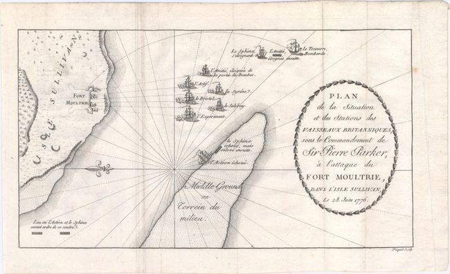
"Plan de la Situation et des Stations des Vaisseaux Britanniques, sous le Commandement de Sir Pierre Parker, a l'Attaque du Fort Moultrie, dans l'Isle Sullivan Le 28 Juin 1776", Ramsay, David

Subject: South Carolina, Revolutionary War

Period: 1787 (circa)

Publication: Histoire de la Revolution d'Amerique, par Rapport a la Caroline Meridionale

Color: Black & White

Size:
11.4 x 6.4 inches
29 x 16.3 cm
Download High Resolution Image
(or just click on image to launch the Zoom viewer)

This uncommon French map depicts an early American Revolution battle scene. In 1776, South Carolina patriots began to build a fort to protect Charleston and its harbor. On June 28th of that same year, British Admiral Sir Peter Parker brought nine ships to attack the fort that was still under construction. The attack was unsuccessful and Parker lost one of his ships in the process, here shown running aground. It wasn't until the Siege of Charleston in 1780 that the British were able to take over the fort. Published in the French edition of Ramsey's The History of the Revolution of South Carolina. Ramsay was a resident of Charleston and is known for his accurate historical reporting. Originally engraved by Thomas Abernethie, a Scottish engraver in Charleston, these maps were re-engraved by Picquet for the French edition.

References: Nebenzahl (Biblio) #86a.

Condition: B+

Issued folding with a few extraneous creases adjacent to the left fold and very faint offsetting.

Estimate: $400 - $500

Sold for: $220

Closed on 2/19/2014

Archived