Catalog Archive
Auction 148, Lot 310

"Plan du Havre de Charleston, Montrant la Disposition de la Flotte Britannique, Commandee par le Vice-Amiral Marie Arbuthnot, a l'Attaque du Fort Moultrie dans l'Isle Sullivan, en 1780", Ramsay, David

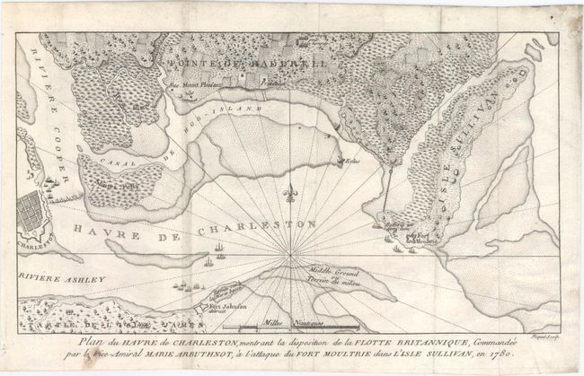
Subject: South Carolina, Revolutionary War

Period: 1787 (circa)

Publication: Histoire de la Revolution d'Amerique, par Rapport a la Caroline Meridionale

Color: Black & White

Size:
11.5 x 6.9 inches
29.2 x 17.5 cm
Download High Resolution Image
(or just click on image to launch the Zoom viewer)

This rare, small map of the Siege of Charleston is from the French edition of Ramsey's The History of the Revolution of South Carolina. It depicts Charleston Harbor and the surrounding area, including Fort Johnson, Fort Moultrie and the fortification at Charleston. Numerous ships are shown in the harbor, including the blockade along the Cooper River.

The Siege of Charleston was a major battle in the Revolutionary War and occurred in the later stages of the war as the British focused their efforts on the colonies to the south. After a six-week battle, the Americans surrendered the largest number of troops in the entire war. Ramsay was a resident of Charleston and is known for his accurate historical reporting. Originally engraved by Thomas Abernethie, a Scottish engraver in Charleston, these maps were re-engraved by Picquet for the French edition.

References: Nebenzahl (Biblio) #85.

Condition: B+

Issued folding on watermarked paper with faint offsetting, a few minor misfolds, and a clean 2.5" tear at lower right that has been professionally repaired. Minor soiling in blank margins.

Estimate: $300 - $400

Sold for: $220

Closed on 2/19/2014

Archived