Catalog Archive
Auction 148, Lot 273

The First Detailed Plan of the Battle of Bunker Hill Published in the United States

"A Plan of the Action at Breeds Hill*, on the 17th of June 1775. Between the American Forces, and the British Troops. *Erroneously Called Bunkers Hill", Smith, Charles

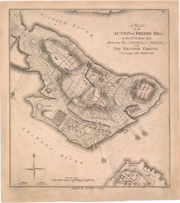
Subject: Boston, Massachusetts

Period: 1796 (published)

Publication: Monthly Military Repository

Color: Hand Color

Size:
8.3 x 9.2 inches
21.1 x 23.4 cm
Download High Resolution Image
(or just click on image to launch the Zoom viewer)

This rare map is a reduced version of Thomas Hyde Page's plan of the Battle of Bunker Hill. Although the battle resulted in a British victory and loss of control of Boston, the campaign was considered one of the first steps towards American independence. Page served as aide-de-campe to General Howe during the action. His plan was first published by Faden and later in Charles Stedman's history of the American Revolution. Smith's edition of the plan, in addition to being publishing in the United States, is important because it correctly identifies Breed's Hill as the site of the battle. It also changes the title to emphasize the American forces: "...between the American Forces, and the British Troops" vs. "...between His Majesty's Troops under the Command of Major General Howe, and the Rebel Forces." The map shows British landing places, lines of attack, movements of the British ships, Warren's Redoubt, and the deployment of the defending forces. The British troops are shown in red with the American forces depicted in blue. Due to the ephemeral nature of Smith's Military Repository, this map is rarely found on the market.

References: Wheat & Brun, #247; cf. Nebenzahl (Biblio) #29.

Condition: B+

Overall toning with minor soiling and margins professionally restored with skilled facsimile of the top neatline.

Estimate: $2,750 - $3,500

Sold for: $2,000

Closed on 2/19/2014

Archived