Catalog Archive
Auction 148, Lot 257

Rare Plan of Georgia Settlement New Ebenezer

"Plan von Neu Ebenezer [on sheet with] [Untitled - Map of Southeast]", Seutter, Matthias
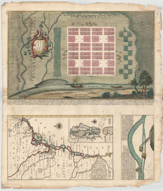
Subject: Georgia

Period: 1747 (circa)

Publication:

Color: Hand Color

Size:
19.8 x 12 inches
50.3 x 30.5 cm
Download High Resolution Image
(or just click on image to launch the Zoom viewer)

This rare map features two separate plates on the same sheet: a town plan of the important Georgia settlement New Ebenezer, as well as a map of the Georgia coast and a representation of New Ebenezer's water mill. Both plates originally appeared in Samuel Urlsperger's third volume of Aussfuhrliche Nachtricht von den Saltzburgischen Emigranten, first published in 1747.

Established by Protestants expelled from Salzburg in 1734 as a "religious utopia," the site for Old Ebenezer proved to be a poor location due to the sterile land. New Ebenezer was settled just two years later, closer to the Savannah River, and it was here that the town prospered until the end of the eighteenth century. Notable for its silk mills and its brief status as the capital of Georgia in 1782, the town deteriorated after being hit particularly hard by the Revolutionary War; by 1855, it was a ghost town. Seutter's orderly grid plan of New Ebenezer shows roads, marketplaces, the church and school, and several other locations, all explained in the key below the map. Surrounding the plan is a perspective view of the waterways around the settlement along with the cattle and woods on the outskirts of town.

The second plate on the sheet displays a section of coastline from the southeastern United States stretching from St. Augustine to southern South Carolina, engraved by T.C. Lotter. Within Georgia, there is a large grid representing Savannah, and several smaller grids marking Ebenezer and other settlements and forts. The territory of the Yamacraw Indians is also identified. An inset depicts the islands of St. Simon and Jekyl. Below the map is a view of a mill at Ebenezer with notes explaining the milling process.

References: Cumming #264-65; Deak #95; Tooley #115.

Condition: B+

On heavy, watermarked paper with attractive color and light damp stains that enter top and bottom corners at right and along centerfold at left. There is a printer's crease that just enters the neatline to the right of the town plan and a number of a chips and tears along sheet edges that do not affect the images.

Estimate: $6,000 - $8,000

Unsold

Closed on 2/19/2014

Archived