Catalog Archive
Auction 148, Lot 206

An Important Map of the Trans-Appalachian Frontier

"Map of the State of Kentucky; with the Adjoining Territories", Russell, John C.

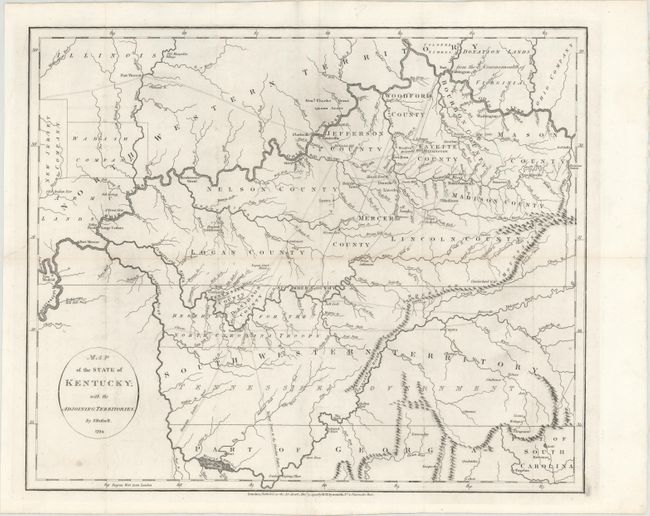
Subject: Tennessee, Kentucky

Period: 1794 (dated)

Publication: An Historical...and Philosophical View of the United States…

Color: Black & White

Size:
18.1 x 14.9 inches
46 x 37.8 cm
Download High Resolution Image
(or just click on image to launch the Zoom viewer)

By the time of the Revolutionary War, the practice of awarding bounty land as an inducement for enlisting in the military had been a long-standing practice in colonial North America. Besides imperial bounty land grants, both colonial and municipal governments routinely compensated participants in and victims of military conflicts with land. Land was a commodity in generous supply, and governments seized upon its availability for accomplishing their goals.

Following this tradition, the Revolutionary governments used bounty land grants in their struggle for independence from Great Britain. They generally offered free lands in exchange for military service, provided they were victorious in their struggle. Thus, bounty lands were an effective technique for enrolling support for the war and encouraging re-enlistments. Generally the bounty lands were located on the western frontier, which provided another benefit to the government. Populating the frontier with citizens skilled in defense offered the best prospect in enticing other settlers to join them, thus eventually increasing the tax rolls.

This is an important map depicting the entire state of Kentucky, most of Tennessee (labeled as South Western Territory), and the northern part of Georgia. The best map of the trans-Appalachian frontier, it was issued only two years after statehood for Kentucky and before Tennessee became a state. Within Kentucky, ten counties are delineated and pioneer roads (called traces) are shown throughout both Kentucky and Tennessee. Towns such as Lexington, Louisville, Nashville, Knoxville, Boonsborough, and even mills and orchards are denoted. Of particular interest are the depictions of the planned, but never built, utopian settlements of Somerset, Lystra, Ohiopionmingo, and Franklinville. Several Bounty Land Grants are shown in the adjacent territory.

References: cf. Wheat & Brun #646.

Condition: B+

Issued folding with faint offsetting, minor toning along one fold, two tiny holes at fold intersections, and a tear at left that just touches the neatline and has been repaired on verso with archival materials.

Estimate: $800 - $1,000

Sold for: $425

Closed on 2/19/2014

Archived