Catalog Archive
Auction 148, Lot 183

One of the Most Important 17th Century Maps of the Chesapeake Bay

"Nova Virginiae Tabula", Hondius/Blaeu

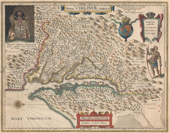
Subject: Colonial Mid-Atlantic United States

Period: 1663 (published)

Publication: Le Grand Atlas

Color: Hand Color

Size:
18.9 x 14.8 inches
48 x 37.6 cm
Download High Resolution Image
(or just click on image to launch the Zoom viewer)

The early settlement of Jamestown is noted as Iamestowne, and there are a number of other place names, both English and Native American. The map was derived from Capt. John Smith's map of 1612, which was the first to depict the bay and its tributaries with any accuracy. In the upper left corner is an engraving of the great Indian chief, Powhatan, seated on his throne and surrounded by his subjects. A Susquehanna chief is depicted on the right under the British coat-of-arms and a key cartouche. The plate was engraved by Dirck Grijp and was originally published by Jodocus Hondius Jr. in 1618. It was purchased by Willem Blaeu shortly after Hondius' death (1629) and Blaeu's imprint replaced that of Hondius. French text on verso.

References: Burden #193; Portinaro & Knirsch KXXIV; Tooley (Amer) p. 161-62; Van der Krogt (Vol. II) #9410:2.2.

Condition: A

A fine impression with attractive color and very generous margins. There is a printer's crease adjacent to centerfold and some minor printer's ink residue.

Estimate: $2,750 - $3,500

Sold for: $2,100

Closed on 2/19/2014

Archived